Vilches geodata
Vilches (Andalusia) is a seat of a third-order administrative division; located in Spain in Europe/Madrid (GMT+2) time zone. With population of 4,929 people, there are 1323 cities with bigger population in this country. Compared to other cities in Spain, 87.1% of cities are located further ↑North; 52.3% of cities are located further →East and 60.2% of cities have higher elevation than Vilches. Note1


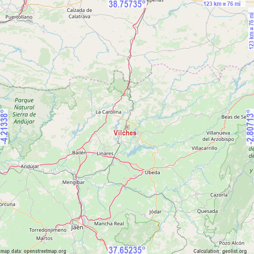
Vilches GPS coordinates[2]
38° 12' 25.02" North, 3° 30' 36.9" West
| Map corner | latitude | longitude |
|---|---|---|
| Upper-left | 38.75735°, | -4.21338° |
| Center: | 38.20695°, | -3.51025° |
| Lower-right: | 37.65235°, | -2.80713° |
| Map W x H: | 122.9×122.9 km | = 76.4×76.4mi |
| max Lat: | 43.74134° ⇑87.1% North |
| Vilches: | 38.20695° |
| min Lat: | ⇓12.9% South 27.64134° |
| min Long | Vilches | max Long |
| -18.00367° | -3.51025° | 4.2899° |
| W 47.7%⇐ | ⇒52.3% E |
Elevation
Elevation of Vilches is 525 m = 1722 ft, and this is 73 m = 240 ft below average elevation for this country.
| Max E: |
1682 m = 5518 ft | 60.2% |
| Avg. | 598 m = 1962 ft | |
| Vilches | 525 m = 1722 ft | |
Min E: |
0 m = 0 ft | 39.8% |
See also: Spain elevation on elevation.city.
Geographical zone
Vilches is located in North temperate zone (between Tropic of Cancer and the Arctic Circle). Distance of this Northern Tropic circle is 1642.3 km =1020.5 mi to South.| Distance of | km | miles | from Vilches |
|---|---|---|---|
| North Pole | 5758.8 | 3578.4 | to North |
| Arctic Circle | 3153 | 1959.2 | to North |
| Tropic Cancer | 1642.3 | 1020.5 | to South |
| Equator | 4248.2 | 2639.7 | to South |


Nearby cities:
15 places around Vilches: (largest is in red/bold)
• Arquillos
7.7 km =4.8 mi,  111°
111°
• Baeza
23.9 km =14.9 mi,  171°
171°
• Baños de la Encina
23.4 km =14.5 mi,  260°
260°
• Canena
17.7 km =11 mi, 172°
• Carboneros
10.9 km =6.8 mi,  283°
283°
• Guarromán
15.7 km =9.8 mi, 260°
• Ibros
20.7 km =12.9 mi,  178°
178°
• La Carolina
11.9 km =7.4 mi,  309°
309°
• Linares
16.6 km =10.3 mi,  221°
221°
• Lupión
23.6 km =14.7 mi,  187°
187°
• Navas de San Juan
17.2 km =10.7 mi,  98°
98°
• Rus
18.2 km =11.3 mi, 166°
• Sabiote
23 km =14.3 mi,  131°
131°
• Santa Elena
15.2 km =9.4 mi,  350°
350°
• Úbeda
24.8 km =15.4 mi,  150°
150°
Sources, notices
• [Note1] Compared only with cities in Spain existing in our database
• [Src1] Map data: © OpenStreetMap contributors (CC-BY-SA)
• [Src2] Other city data from geonames.org with taken over terms of usage.
• [Src3] Geographical zone / Annual Mean Temperature by Robert A. Rohde @ Wikipedia
