Úbeda geodata
Úbeda (Andalusia) is a seat of a third-order administrative division; located in Spain in Europe/Madrid (GMT+2) time zone. With population of 35,649 people, there are 251 cities with bigger population in this country. Compared to other cities in Spain, 88.5% of cities are located further ↑North; 50.5% of cities are located further →East and 63.2% of cities have lower elevation than Úbeda. Note1


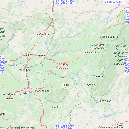
Úbeda GPS coordinates[2]
38° 0' 47.808" North, 3° 22' 13.8" West
| Map corner | latitude | longitude |
|---|---|---|
| Upper-left | 38.56515°, | -4.07362° |
| Center: | 38.01328°, | -3.3705° |
| Lower-right: | 37.45722°, | -2.66737° |
| Map W x H: | 123.2×123.2 km | = 76.6×76.6mi |
| max Lat: | 43.74134° ⇑88.5% North |
| Úbeda: | 38.01328° |
| min Lat: | ⇓11.5% South 27.64134° |
| min Long | Úbeda | max Long |
| -18.00367° | -3.3705° | 4.2899° |
| W 49.5%⇐ | ⇒50.5% E |
Elevation
Elevation of Úbeda is 766 m = 2513 ft, and this is 168 m = 551 ft above average elevation for this country.
| Max E: |
1682 m = 5518 ft | 36.8% |
| Úbeda | 766 m 2513 ft | |
| Avg. | 598 m = 1962 ft | |
Min E: |
0 m = 0 ft | 63.2% |
See also: Spain elevation on elevation.city.
Geographical zone
Úbeda is located in North temperate zone (between Tropic of Cancer and the Arctic Circle). Distance of this Northern Tropic circle is 1620.8 km =1007.1 mi to South.| Distance of | km | miles | from Úbeda |
|---|---|---|---|
| North Pole | 5780.4 | 3591.8 | to North |
| Arctic Circle | 3174.5 | 1972.5 | to North |
| Tropic Cancer | 1620.8 | 1007.1 | to South |
| Equator | 4226.7 | 2626.3 | to South |


Nearby cities:
15 places around Úbeda: (largest is in red/bold)
• Arquillos
19.4 km =12.1 mi,  344°
344°
• Baeza
9.1 km =5.7 mi,  256°
256°
• Begíjar
14.4 km =8.9 mi, 257°
• Canena
10.6 km =6.6 mi,  292°
292°
• Hornos
21.3 km =13.2 mi,  131°
131°
• Ibros
11.7 km =7.3 mi,  274°
274°
• Jimena
21.3 km =13.2 mi,  206°
206°
• Jódar
19.3 km =12 mi,  175°
175°
• Lupión
15.6 km =9.7 mi, 263°
• Navas de San Juan
19.6 km =12.2 mi,  14°
14°
• Rus
8.9 km =5.5 mi,  295°
295°
• Sabiote
7.9 km =4.9 mi,  38°
38°
• Solana de Torralba
17.6 km =10.9 mi,  99°
99°
• Torreblascopedro
23.5 km =14.6 mi, 265°
• Torreperogil
7.5 km =4.7 mi,  70°
70°
Sources, notices
• [Note1] Compared only with cities in Spain existing in our database
• [Src1] Map data: © OpenStreetMap contributors (CC-BY-SA)
• [Src2] Other city data from geonames.org with taken over terms of usage.
• [Src3] Geographical zone / Annual Mean Temperature by Robert A. Rohde @ Wikipedia
