Lupión geodata
Lupión (Andalusia) is a seat of a third-order administrative division; located in Spain in Europe/Madrid (GMT+2) time zone. With population of 1,008 people, there are 2931 cities with bigger population in this country. Compared to other cities in Spain, 88.6% of cities are located further ↑North; 52.9% of cities are located further →East and 61.6% of cities have higher elevation than Lupión. Note1


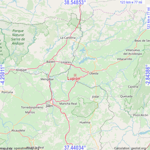
Lupión GPS coordinates[2]
37° 59' 47.508" North, 3° 32' 49.164" West
| Map corner | latitude | longitude |
|---|---|---|
| Upper-left | 38.54853°, | -4.25011° |
| Center: | 37.99653°, | -3.54699° |
| Lower-right: | 37.44034°, | -2.84386° |
| Map W x H: | 123.2×123.2 km | = 76.6×76.6mi |
| max Lat: | 43.74134° ⇑88.6% North |
| Lupión: | 37.99653° |
| min Lat: | ⇓11.4% South 27.64134° |
| min Long | Lupión | max Long |
| -18.00367° | -3.54699° | 4.2899° |
| W 47.1%⇐ | ⇒52.9% E |
Elevation
Elevation of Lupión is 503 m = 1650 ft, and this is 95 m = 312 ft below average elevation for this country.
| Max E: |
1682 m = 5518 ft | 61.6% |
| Avg. | 598 m = 1962 ft | |
| Lupión | 503 m = 1650 ft | |
Min E: |
0 m = 0 ft | 38.4% |
See also: Spain elevation on elevation.city.
Geographical zone
Lupión is located in North temperate zone (between Tropic of Cancer and the Arctic Circle). Distance of this Northern Tropic circle is 1618.9 km =1005.9 mi to South.| Distance of | km | miles | from Lupión |
|---|---|---|---|
| North Pole | 5782.2 | 3592.9 | to North |
| Arctic Circle | 3176.4 | 1973.7 | to North |
| Tropic Cancer | 1618.9 | 1005.9 | to South |
| Equator | 4224.8 | 2625.2 | to South |


Nearby cities:
15 places around Lupión: (largest is in red/bold)
• Arquillos
23 km =14.3 mi,  26°
26°
• Baeza
6.7 km =4.2 mi,  92°
92°
• Bailén
23.1 km =14.4 mi,  298°
298°
• Begíjar
1.9 km =1.2 mi,  132°
132°
• Canena
8.1 km =5 mi,  43°
43°
• Ibros
4.7 km =2.9 mi,  54°
54°
• Jabalquinto
15.8 km =9.8 mi,  279°
279°
• Jimena
18.3 km =11.4 mi,  160°
160°
• Linares
13.5 km =8.4 mi,  324°
324°
• Mengibar
23.1 km =14.4 mi,  262°
262°
• Rus
9.3 km =5.8 mi, 52°
• Sabiote
21.9 km =13.6 mi,  68°
68°
• Torreblascopedro
8 km =5 mi,  270°
270°
• Torreperogil
22.9 km =14.2 mi,  79°
79°
• Úbeda
15.6 km =9.7 mi, 83°
Sources, notices
• [Note1] Compared only with cities in Spain existing in our database
• [Src1] Map data: © OpenStreetMap contributors (CC-BY-SA)
• [Src2] Other city data from geonames.org with taken over terms of usage.
• [Src3] Geographical zone / Annual Mean Temperature by Robert A. Rohde @ Wikipedia
