Canena geodata
Canena (Andalusia) is a seat of a third-order administrative division; located in Spain in Europe/Madrid (GMT+2) time zone. With population of 2,093 people, there are 2103 cities with bigger population in this country. Compared to other cities in Spain, 88.2% of cities are located further ↑North; 51.9% of cities are located further →East and 60.7% of cities have higher elevation than Canena. Note1


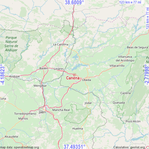
Canena GPS coordinates[2]
38° 2' 57.48" North, 3° 28' 59.16" West
| Map corner | latitude | longitude |
|---|---|---|
| Upper-left | 38.6009°, | -4.18623° |
| Center: | 38.0493°, | -3.4831° |
| Lower-right: | 37.49351°, | -2.77998° |
| Map W x H: | 123.1×123.1 km | = 76.5×76.5mi |
| max Lat: | 43.74134° ⇑88.2% North |
| Canena: | 38.0493° |
| min Lat: | ⇓11.8% South 27.64134° |
| min Long | Canena | max Long |
| -18.00367° | -3.4831° | 4.2899° |
| W 48.1%⇐ | ⇒51.9% E |
Elevation
Elevation of Canena is 518 m = 1699 ft, and this is 80 m = 262 ft below average elevation for this country.
| Max E: |
1682 m = 5518 ft | 60.7% |
| Avg. | 598 m = 1962 ft | |
| Canena | 518 m = 1699 ft | |
Min E: |
0 m = 0 ft | 39.3% |
See also: Spain elevation on elevation.city.
Geographical zone
Canena is located in North temperate zone (between Tropic of Cancer and the Arctic Circle). Distance of this Northern Tropic circle is 1624.8 km =1009.6 mi to South.| Distance of | km | miles | from Canena |
|---|---|---|---|
| North Pole | 5776.4 | 3589.3 | to North |
| Arctic Circle | 3170.5 | 1970.1 | to North |
| Tropic Cancer | 1624.8 | 1009.6 | to South |
| Equator | 4230.7 | 2628.8 | to South |


Nearby cities:
15 places around Canena: (largest is in red/bold)
• Arquillos
15.5 km =9.6 mi,  18°
18°
• Baeza
6.3 km =3.9 mi,  170°
170°
• Begíjar
8.3 km =5.2 mi,  210°
210°
• Ibros
3.6 km =2.2 mi, 209°
• Jabalquinto
21.5 km =13.4 mi,  261°
261°
• Jimena
23.1 km =14.4 mi,  178°
178°
• Linares
14.3 km =8.9 mi,  290°
290°
• Lupión
8.1 km =5 mi,  223°
223°
• Navas de San Juan
20.9 km =13 mi,  44°
44°
• Rus
1.8 km =1.1 mi,  96°
96°
• Sabiote
14.9 km =9.3 mi,  81°
81°
• Torreblascopedro
14.7 km =9.1 mi,  246°
246°
• Torreperogil
17 km =10.6 mi, 95°
• Vilches
17.7 km =11 mi,  352°
352°
• Úbeda
10.6 km =6.6 mi,  112°
112°
Sources, notices
• [Note1] Compared only with cities in Spain existing in our database
• [Src1] Map data: © OpenStreetMap contributors (CC-BY-SA)
• [Src2] Other city data from geonames.org with taken over terms of usage.
• [Src3] Geographical zone / Annual Mean Temperature by Robert A. Rohde @ Wikipedia
