Baeza geodata
Baeza (Andalusia) is a seat of a third-order administrative division; located in Spain in Europe/Madrid (GMT+2) time zone. With population of 16,253 people, there are 577 cities with bigger population in this country. Compared to other cities in Spain, 88.6% of cities are located further ↑North; 51.7% of cities are located further →East and 62.7% of cities have lower elevation than Baeza. Note1


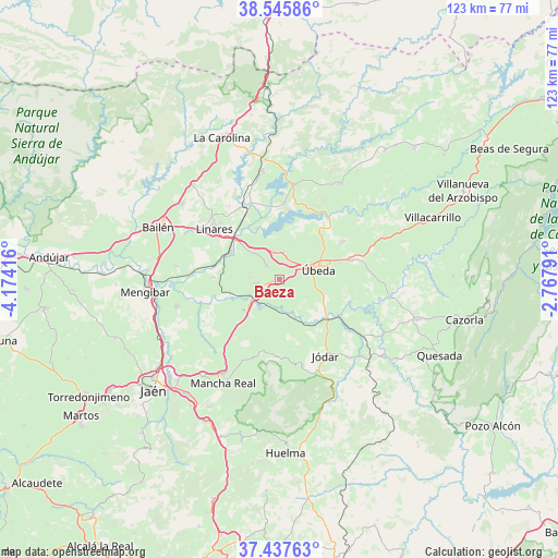
Baeza GPS coordinates[2]
37° 59' 37.824" North, 3° 28' 15.708" West
| Map corner | latitude | longitude |
|---|---|---|
| Upper-left | 38.54586°, | -4.17416° |
| Center: | 37.99384°, | -3.47103° |
| Lower-right: | 37.43763°, | -2.76791° |
| Map W x H: | 123.2×123.2 km | = 76.6×76.6mi |
| max Lat: | 43.74134° ⇑88.6% North |
| Baeza: | 37.99384° |
| min Lat: | ⇓11.4% South 27.64134° |
| min Long | Baeza | max Long |
| -18.00367° | -3.47103° | 4.2899° |
| W 48.3%⇐ | ⇒51.7% E |
Elevation
Elevation of Baeza is 763 m = 2503 ft, and this is 165 m = 541 ft above average elevation for this country.
| Max E: |
1682 m = 5518 ft | 37.3% |
| Baeza | 763 m 2503 ft | |
| Avg. | 598 m = 1962 ft | |
Min E: |
0 m = 0 ft | 62.7% |
See also: Spain elevation on elevation.city.
Geographical zone
Baeza is located in North temperate zone (between Tropic of Cancer and the Arctic Circle). Distance of this Northern Tropic circle is 1618.6 km =1005.8 mi to South.| Distance of | km | miles | from Baeza |
|---|---|---|---|
| North Pole | 5782.5 | 3593.1 | to North |
| Arctic Circle | 3176.7 | 1973.9 | to North |
| Tropic Cancer | 1618.6 | 1005.8 | to South |
| Equator | 4224.5 | 2625 | to South |


Nearby cities:
15 places around Baeza: (largest is in red/bold)
• Arquillos
21.2 km =13.2 mi,  10°
10°
• Begíjar
5.3 km =3.3 mi,  259°
259°
• Canena
6.3 km =3.9 mi,  350°
350°
• Ibros
4.1 km =2.5 mi,  317°
317°
• Jabalquinto
22.4 km =13.9 mi,  277°
277°
• Jimena
16.9 km =10.5 mi,  181°
181°
• Jódar
20 km =12.4 mi,  148°
148°
• Linares
18.3 km =11.4 mi,  307°
307°
• Lupión
6.7 km =4.2 mi,  272°
272°
• Rus
6 km =3.7 mi, 7°
• Sabiote
16.1 km =10 mi,  58°
58°
• Torreblascopedro
14.6 km =9.1 mi, 271°
• Torreperogil
16.5 km =10.3 mi,  73°
73°
• Torres
23.4 km =14.5 mi,  188°
188°
• Úbeda
9.1 km =5.7 mi,  76°
76°
Sources, notices
• [Note1] Compared only with cities in Spain existing in our database
• [Src1] Map data: © OpenStreetMap contributors (CC-BY-SA)
• [Src2] Other city data from geonames.org with taken over terms of usage.
• [Src3] Geographical zone / Annual Mean Temperature by Robert A. Rohde @ Wikipedia
