Montellano geodata
Montellano (Andalusia) is a seat of a third-order administrative division; located in Spain in Europe/Madrid (GMT+2) time zone. With population of 6,851 people, there are 1051 cities with bigger population in this country. Compared to other cities in Spain, 95.3% of cities are located further ↑North; 79.7% of cities are located further →East and 77.6% of cities have higher elevation than Montellano. Note1


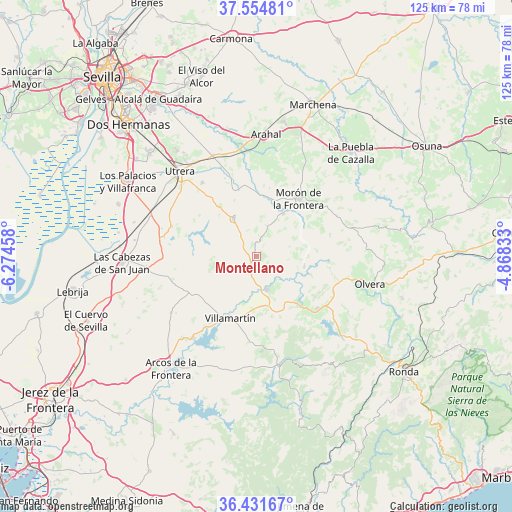
Montellano GPS coordinates[2]
36° 59' 43.116" North, 5° 34' 17.22" West
| Map corner | latitude | longitude |
|---|---|---|
| Upper-left | 37.55481°, | -6.27458° |
| Center: | 36.99531°, | -5.57145° |
| Lower-right: | 36.43167°, | -4.86833° |
| Map W x H: | 124.9×124.9 km | = 77.6×77.6mi |
| max Lat: | 43.74134° ⇑95.3% North |
| Montellano: | 36.99531° |
| min Lat: | ⇓4.7% South 27.64134° |
| min Long | Montellano | max Long |
| -18.00367° | -5.57145° | 4.2899° |
| W 20.3%⇐ | ⇒79.7% E |
Elevation
Elevation of Montellano is 262 m = 860 ft, and this is 336 m = 1102 ft below average elevation for this country.
| Max E: |
1682 m = 5518 ft | 77.6% |
| Avg. | 598 m = 1962 ft | |
| Montellano | 262 m = 860 ft | |
Min E: |
0 m = 0 ft | 22.4% |
See also: Spain elevation on elevation.city.
Geographical zone
Montellano is located in North temperate zone (between Tropic of Cancer and the Arctic Circle). Distance of this Northern Tropic circle is 1507.6 km =936.8 mi to South.| Distance of | km | miles | from Montellano |
|---|---|---|---|
| North Pole | 5893.6 | 3662.1 | to North |
| Arctic Circle | 3287.7 | 2042.9 | to North |
| Tropic Cancer | 1507.6 | 936.8 | to South |
| Equator | 4113.5 | 2556 | to South |


Nearby cities:
15 places around Montellano: (largest is in red/bold)
• Algodonales
19.5 km =12.1 mi,  130°
130°
• Bornos
25.1 km =15.6 mi,  217°
217°
• Coripe
11.9 km =7.4 mi,  101°
101°
• El Bosque
27 km =16.8 mi,  167°
167°
• El Coronil
10.9 km =6.8 mi,  329°
329°
• El Gastor
27 km =16.8 mi, 125°
• Espera
24.8 km =15.4 mi,  237°
237°
• Los Molares
22.2 km =13.8 mi,  324°
324°
• Morón de la Frontera
17.4 km =10.8 mi,  36°
36°
• Olvera
27.9 km =17.3 mi, 104°
• Prado del Rey
23.1 km =14.4 mi,  176°
176°
• Puerto Serrano
8.5 km =5.3 mi,  162°
162°
• Utrera
28.1 km =17.5 mi, 318°
• Villamartín
16.4 km =10.2 mi,  203°
203°
• Zahara
23.5 km =14.6 mi,  137°
137°
Sources, notices
• [Note1] Compared only with cities in Spain existing in our database
• [Src1] Map data: © OpenStreetMap contributors (CC-BY-SA)
• [Src2] Other city data from geonames.org with taken over terms of usage.
• [Src3] Geographical zone / Annual Mean Temperature by Robert A. Rohde @ Wikipedia
