Malagón geodata
Malagón (Castille-La Mancha) is a seat of a third-order administrative division; located in Spain in Europe/Madrid (GMT+2) time zone. With population of 7,923 people, there are 945 cities with bigger population in this country. Compared to other cities in Spain, 79.7% of cities are located further ↑North; 57.6% of cities are located further →East and 51.9% of cities have higher elevation than Malagón. Note1
Administrative division(s):
- Level 1: Castille-La Mancha
- Level 2: Provincia de Ciudad Real
- Level 3: Malagón


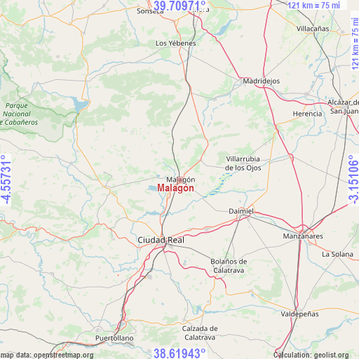
Malagón GPS coordinates[2]
39° 10' 0.048" North, 3° 51' 15.084" West
| Map corner | latitude | longitude |
|---|---|---|
| Upper-left | 39.70971°, | -4.55731° |
| Center: | 39.16668°, | -3.85419° |
| Lower-right: | 38.61943°, | -3.15106° |
| Map W x H: | 121.2×121.2 km | = 75.3×75.3mi |
| max Lat: | 43.74134° ⇑79.7% North |
| Malagón: | 39.16668° |
| min Lat: | ⇓20.3% South 27.64134° |
| min Long | Malagón | max Long |
| -18.00367° | -3.85419° | 4.2899° |
| W 42.4%⇐ | ⇒57.6% E |
Elevation
Elevation of Malagón is 638 m = 2093 ft, and this is 40 m = 131 ft above average elevation for this country.
| Max E: |
1682 m = 5518 ft | 51.9% |
| Malagón | 638 m 2093 ft | |
| Avg. | 598 m = 1962 ft | |
Min E: |
0 m = 0 ft | 48.1% |
See also: Spain elevation on elevation.city.
Geographical zone
Malagón is located in North temperate zone (between Tropic of Cancer and the Arctic Circle). Distance of this Northern Tropic circle is 1749 km =1086.8 mi to South.| Distance of | km | miles | from Malagón |
|---|---|---|---|
| North Pole | 5652.1 | 3512.1 | to North |
| Arctic Circle | 3046.2 | 1892.8 | to North |
| Tropic Cancer | 1749 | 1086.8 | to South |
| Equator | 4354.9 | 2706 | to South |


Nearby cities:
15 places around Malagón: (largest is in red/bold)
• Alcolea de Calatrava
30.2 km =18.8 mi,  228°
228°
• Arenas de San Juan
30.9 km =19.2 mi,  79°
79°
• Ballesteros
15.4 km =9.6 mi,  321°
321°
• Carrión de Calatrava
16.7 km =10.4 mi,  168°
168°
• Ciudad Real
21.1 km =13.1 mi,  197°
197°
• Daimiel
23.3 km =14.5 mi,  117°
117°
• Fuencaliente
14.9 km =9.3 mi,  278°
278°
• Fuente el Fresno
9.7 km =6 mi,  44°
44°
• Miguelturra
22.7 km =14.1 mi,  187°
187°
• Picón
22 km =13.7 mi, 234°
• Poblete
28 km =17.4 mi, 203°
• Porzuna
26 km =16.2 mi,  264°
264°
• Torralba de Calatrava
18.8 km =11.7 mi,  151°
151°
• Urda
29.8 km =18.5 mi,  23°
23°
• Villarrubia de los Ojos
22.1 km =13.7 mi,  74°
74°
Sources, notices
• [Note1] Compared only with cities in Spain existing in our database
• [Src1] Map data: © OpenStreetMap contributors (CC-BY-SA)
• [Src2] Other city data from geonames.org with taken over terms of usage.
• [Src3] Geographical zone / Annual Mean Temperature by Robert A. Rohde @ Wikipedia
