Los Corrales geodata
Los Corrales (Andalusia) is a populated place; located in Spain in Europe/Madrid (GMT+2) time zone. With population of 4,077 people, there are 1458 cities with bigger population in this country. Compared to other cities in Spain, 94.8% of cities are located further ↑North; 72.3% of cities are located further →East and 70.2% of cities have higher elevation than Los Corrales. Note1


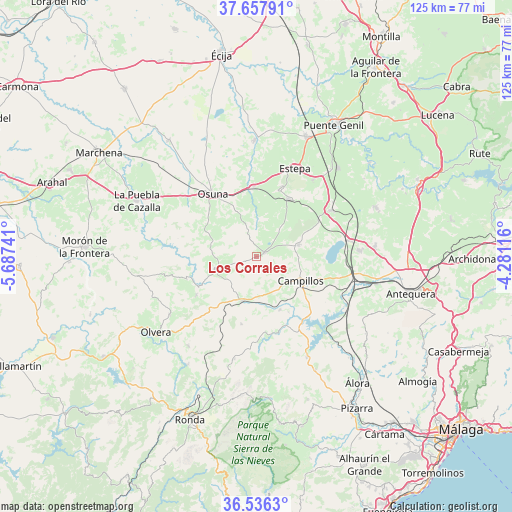
Los Corrales GPS coordinates[2]
37° 5' 57.048" North, 4° 59' 3.444" West
| Map corner | latitude | longitude |
|---|---|---|
| Upper-left | 37.65791°, | -5.68741° |
| Center: | 37.09918°, | -4.98429° |
| Lower-right: | 36.5363°, | -4.28116° |
| Map W x H: | 124.7×124.7 km | = 77.5×77.5mi |
| max Lat: | 43.74134° ⇑94.8% North |
| Los Corrales: | 37.09918° |
| min Lat: | ⇓5.2% South 27.64134° |
| min Long | Los Corrales | max Long |
| -18.00367° | -4.98429° | 4.2899° |
| W 27.7%⇐ | ⇒72.3% E |
Elevation
Elevation of Los Corrales is 377 m = 1237 ft, and this is 221 m = 725 ft below average elevation for this country.
| Max E: |
1682 m = 5518 ft | 70.2% |
| Avg. | 598 m = 1962 ft | |
| Los Corrales | 377 m = 1237 ft | |
Min E: |
0 m = 0 ft | 29.8% |
See also: Spain elevation on elevation.city.
Geographical zone
Los Corrales is located in North temperate zone (between Tropic of Cancer and the Arctic Circle). Distance of this Northern Tropic circle is 1519.1 km =943.9 mi to South.| Distance of | km | miles | from Los Corrales |
|---|---|---|---|
| North Pole | 5882 | 3654.9 | to North |
| Arctic Circle | 3276.1 | 2035.7 | to North |
| Tropic Cancer | 1519.1 | 943.9 | to South |
| Equator | 4125 | 2563.2 | to South |


Nearby cities:
15 places around Los Corrales: (largest is in red/bold)
• Aguadulce
17.1 km =10.6 mi,  357°
357°
• Algámitas
17.4 km =10.8 mi,  237°
237°
• Almargen
11.3 km =7 mi,  197°
197°
• Campillos
12.2 km =7.6 mi,  117°
117°
• Cañete la Real
16.8 km =10.4 mi,  192°
192°
• El Saucejo
10.5 km =6.5 mi,  253°
253°
• Fuente de Piedra
22.9 km =14.2 mi,  79°
79°
• Gilena
18 km =11.2 mi,  20°
20°
• La Roda de Andalucía
21.7 km =13.5 mi,  57°
57°
• Martín de la Jara
2.1 km =1.3 mi, 60°
• Osuna
18.6 km =11.6 mi,  325°
325°
• Pedrera
16.2 km =10.1 mi,  29°
29°
• Sierra de Yeguas
10.7 km =6.6 mi,  74°
74°
• Teba
14.1 km =8.8 mi,  155°
155°
• Villanueva de San Juan
17.8 km =11.1 mi, 251°
Sources, notices
• [Note1] Compared only with cities in Spain existing in our database
• [Src1] Map data: © OpenStreetMap contributors (CC-BY-SA)
• [Src2] Other city data from geonames.org with taken over terms of usage.
• [Src3] Geographical zone / Annual Mean Temperature by Robert A. Rohde @ Wikipedia
