Almargen geodata
Almargen (Andalusia) is a seat of a third-order administrative division; located in Spain in Europe/Madrid (GMT+2) time zone. With population of 2,054 people, there are 2128 cities with bigger population in this country. Compared to other cities in Spain, 95.2% of cities are located further ↑North; 72.8% of cities are located further →East and 61.1% of cities have higher elevation than Almargen. Note1


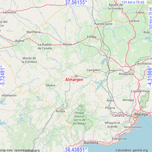
Almargen GPS coordinates[2]
37° 0' 7.56" North, 5° 1' 18.408" West
| Map corner | latitude | longitude |
|---|---|---|
| Upper-left | 37.56155°, | -5.72491° |
| Center: | 37.0021°, | -5.02178° |
| Lower-right: | 36.43851°, | -4.31866° |
| Map W x H: | 124.9×124.9 km | = 77.6×77.6mi |
| max Lat: | 43.74134° ⇑95.2% North |
| Almargen: | 37.0021° |
| min Lat: | ⇓4.8% South 27.64134° |
| min Long | Almargen | max Long |
| -18.00367° | -5.02178° | 4.2899° |
| W 27.2%⇐ | ⇒72.8% E |
Elevation
Elevation of Almargen is 511 m = 1677 ft, and this is 87 m = 285 ft below average elevation for this country.
| Max E: |
1682 m = 5518 ft | 61.1% |
| Avg. | 598 m = 1962 ft | |
| Almargen | 511 m = 1677 ft | |
Min E: |
0 m = 0 ft | 38.9% |
See also: Spain elevation on elevation.city.
Geographical zone
Almargen is located in North temperate zone (between Tropic of Cancer and the Arctic Circle). Distance of this Northern Tropic circle is 1508.3 km =937.2 mi to South.| Distance of | km | miles | from Almargen |
|---|---|---|---|
| North Pole | 5892.8 | 3661.6 | to North |
| Arctic Circle | 3286.9 | 2042.4 | to North |
| Tropic Cancer | 1508.3 | 937.2 | to South |
| Equator | 4114.2 | 2556.4 | to South |


Nearby cities:
15 places around Almargen: (largest is in red/bold)
• Alcalá del Valle
17.2 km =10.7 mi,  230°
230°
• Algámitas
11.4 km =7.1 mi,  277°
277°
• Ardales
20.8 km =12.9 mi,  131°
131°
• Campillos
15 km =9.3 mi,  69°
69°
• Cañete la Real
5.6 km =3.5 mi,  182°
182°
• Cuevas del Becerro
14.2 km =8.8 mi,  188°
188°
• El Saucejo
10.3 km =6.4 mi,  319°
319°
• Los Corrales
11.3 km =7 mi,  17°
17°
• Martín de la Jara
12.9 km =8 mi, 23°
• Pruna
18.1 km =11.2 mi,  259°
259°
• Serrato
13.5 km =8.4 mi,  164°
164°
• Setenil de las Bodegas
20.9 km =13 mi,  222°
222°
• Sierra de Yeguas
19.3 km =12 mi,  45°
45°
• Teba
9.3 km =5.8 mi,  102°
102°
• Villanueva de San Juan
14.6 km =9.1 mi,  291°
291°
Sources, notices
• [Note1] Compared only with cities in Spain existing in our database
• [Src1] Map data: © OpenStreetMap contributors (CC-BY-SA)
• [Src2] Other city data from geonames.org with taken over terms of usage.
• [Src3] Geographical zone / Annual Mean Temperature by Robert A. Rohde @ Wikipedia
