Pechina geodata
Pechina (Andalusia) is a seat of a third-order administrative division; located in Spain in Europe/Madrid (GMT+2) time zone. In our database, there are 6762 cities with bigger population. Compared to other cities in Spain, 96% of cities are located further ↑North; 61.7% of cities are located further ←West and 87.2% of cities have higher elevation than Pechina. Note1


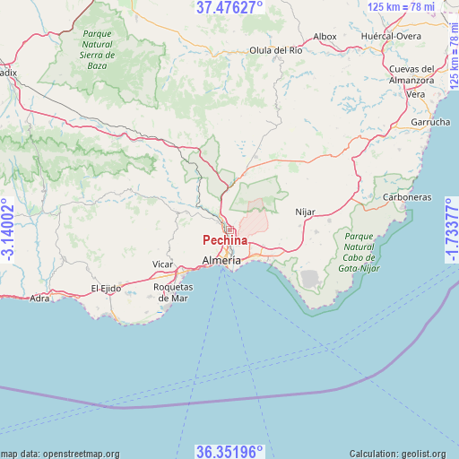
Pechina GPS coordinates[2]
36° 54' 58.284" North, 2° 26' 12.804" West
| Map corner | latitude | longitude |
|---|---|---|
| Upper-left | 37.47627°, | -3.14002° |
| Center: | 36.91619°, | -2.43689° |
| Lower-right: | 36.35196°, | -1.73377° |
| Map W x H: | 125×125 km | = 77.7×77.7mi |
| max Lat: | 43.74134° ⇑96% North |
| Pechina: | 36.91619° |
| min Lat: | ⇓4% South 27.64134° |
| min Long | Pechina | max Long |
| -18.00367° | -2.43689° | 4.2899° |
| W 61.7%⇐ | ⇒38.3% E |
Elevation
Elevation of Pechina is 108 m = 354 ft, and this is 490 m = 1608 ft below average elevation for this country.
| Max E: |
1682 m = 5518 ft | 87.2% |
| Avg. | 598 m = 1962 ft | |
| Pechina | 108 m = 354 ft | |
Min E: |
0 m = 0 ft | 12.8% |
See also: Spain elevation on elevation.city.
Geographical zone
Pechina is located in North temperate zone (between Tropic of Cancer and the Arctic Circle). Distance of this Northern Tropic circle is 1498.8 km =931.3 mi to South.| Distance of | km | miles | from Pechina |
|---|---|---|---|
| North Pole | 5902.4 | 3667.6 | to North |
| Arctic Circle | 3296.5 | 2048.3 | to North |
| Tropic Cancer | 1498.8 | 931.3 | to South |
| Equator | 4104.7 | 2550.5 | to South |


Nearby cities:
15 places around Pechina: (largest is in red/bold)
• Alhabia
15.6 km =9.7 mi,  301°
301°
• Alhama de Almería
12.6 km =7.8 mi,  291°
291°
• Alicún
15.7 km =9.8 mi, 290°
• Almería
8.9 km =5.5 mi,  193°
193°
• Benahadux
2.2 km =1.4 mi, 295°
• Costacabana
10 km =6.2 mi,  150°
150°
• Enix
15.3 km =9.5 mi,  253°
253°
• Gádor
6.4 km =4 mi,  309°
309°
• Huércal de Almería
3.5 km =2.2 mi,  181°
181°
• Retamar
14.2 km =8.8 mi,  130°
130°
• Rioja
4 km =2.5 mi,  324°
324°
• Santa Fe de Mondújar
10.6 km =6.6 mi, 307°
• Tabernas
15.4 km =9.6 mi,  15°
15°
• Terque
16.1 km =10 mi, 297°
• Viator
3 km =1.9 mi,  163°
163°
Sources, notices
• [Note1] Compared only with cities in Spain existing in our database
• [Src1] Map data: © OpenStreetMap contributors (CC-BY-SA)
• [Src2] Other city data from geonames.org with taken over terms of usage.
• [Src3] Geographical zone / Annual Mean Temperature by Robert A. Rohde @ Wikipedia
