Priego de Córdoba geodata
Priego de Córdoba (Andalusia) is a seat of a third-order administrative division; located in Spain in Europe/Madrid (GMT+2) time zone. With population of 23,513 people, there are 397 cities with bigger population in this country. Compared to other cities in Spain, 91.6% of cities are located further ↑North; 62.6% of cities are located further →East and 50.2% of cities have lower elevation than Priego de Córdoba. Note1
Administrative division(s):
- Level 1: Andalusia
- Level 2: Province of Córdoba
- Level 3: Priego de Córdoba


Priego de Córdoba GPS coordinates[2]
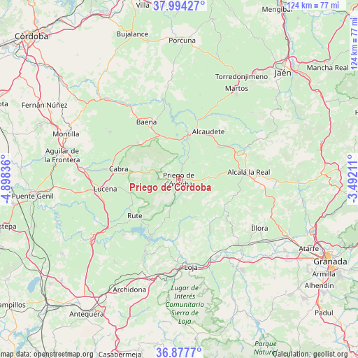
37° 26' 17.052" North, 4° 11' 42.828" West
| Map corner | latitude | longitude |
|---|---|---|
| Upper-left | 37.99427°, | -4.89836° |
| Center: | 37.43807°, | -4.19523° |
| Lower-right: | 36.8777°, | -3.49211° |
| Map W x H: | 124.2×124.2 km | = 77.2×77.2mi |
| max Lat: | 43.74134° ⇑91.6% North |
| Priego de Córdoba: | 37.43807° |
| min Lat: | ⇓8.4% South 27.64134° |
| min Long | Priego de Córd | max Long |
| -18.00367° | -4.19523° | 4.2899° |
| W 37.4%⇐ | ⇒62.6% E |
Elevation
Elevation of Priego de Córdoba is 661 m = 2169 ft, and this is 63 m = 207 ft above average elevation for this country.
| Max E: |
1682 m = 5518 ft | 49.8% |
| Priego de Córdoba | 661 m 2169 ft | |
| Avg. | 598 m = 1962 ft | |
Min E: |
0 m = 0 ft | 50.2% |
See also: Spain elevation on elevation.city.
Geographical zone
Priego de Córdoba is located in North temperate zone (between Tropic of Cancer and the Arctic Circle). Distance of this Northern Tropic circle is 1556.8 km =967.4 mi to South.| Distance of | km | miles | from Priego de Córdoba |
|---|---|---|---|
| North Pole | 5844.3 | 3631.5 | to North |
| Arctic Circle | 3238.5 | 2012.3 | to North |
| Tropic Cancer | 1556.8 | 967.4 | to South |
| Equator | 4162.7 | 2586.6 | to South |


Nearby cities:
15 places around Priego de Córdoba: (largest is in red/bold)
• Alcalá la Real
24.2 km =15 mi,  83°
83°
• Alcaudete
19.7 km =12.2 mi,  30°
30°
• Algarinejo
13 km =8.1 mi,  165°
165°
• Almedinilla
9.2 km =5.7 mi,  89°
89°
• Baena
22.8 km =14.2 mi,  330°
330°
• Cabra
22.1 km =13.7 mi,  279°
279°
• Carcabuey
7 km =4.3 mi, 275°
• Doña Mencía
19.1 km =11.9 mi,  312°
312°
• Fuente-Tójar
9.2 km =5.7 mi, 28°
• Iznájar
22.4 km =13.9 mi,  206°
206°
• Luque
15.3 km =9.5 mi, 330°
• Montefrío
20.8 km =12.9 mi,  127°
127°
• Rute
19.7 km =12.2 mi,  231°
231°
• Zagra
20.4 km =12.7 mi, 173°
• Zuheros
15.8 km =9.8 mi,  317°
317°
Sources, notices
• [Note1] Compared only with cities in Spain existing in our database
• [Src1] Map data: © OpenStreetMap contributors (CC-BY-SA)
• [Src2] Other city data from geonames.org with taken over terms of usage.
• [Src3] Geographical zone / Annual Mean Temperature by Robert A. Rohde @ Wikipedia
