Pruna geodata
Pruna (Andalusia) is a seat of a third-order administrative division; located in Spain in Europe/Madrid (GMT+2) time zone. With population of 3,047 people, there are 1709 cities with bigger population in this country. Compared to other cities in Spain, 95.6% of cities are located further ↑North; 75.4% of cities are located further →East and 58.8% of cities have higher elevation than Pruna. Note1


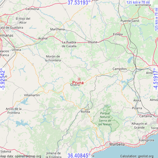
Pruna GPS coordinates[2]
36° 58' 20.136" North, 5° 13' 20.28" West
| Map corner | latitude | longitude |
|---|---|---|
| Upper-left | 37.53193°, | -5.92542° |
| Center: | 36.97226°, | -5.2223° |
| Lower-right: | 36.40845°, | -4.51917° |
| Map W x H: | 124.9×124.9 km | = 77.6×77.6mi |
| max Lat: | 43.74134° ⇑95.6% North |
| Pruna: | 36.97226° |
| min Lat: | ⇓4.4% South 27.64134° |
| min Long | Pruna | max Long |
| -18.00367° | -5.2223° | 4.2899° |
| W 24.6%⇐ | ⇒75.4% E |
Elevation
Elevation of Pruna is 543 m = 1781 ft, and this is 55 m = 180 ft below average elevation for this country.
| Max E: |
1682 m = 5518 ft | 58.8% |
| Avg. | 598 m = 1962 ft | |
| Pruna | 543 m = 1781 ft | |
Min E: |
0 m = 0 ft | 41.2% |
See also: Spain elevation on elevation.city.
Geographical zone
Pruna is located in North temperate zone (between Tropic of Cancer and the Arctic Circle). Distance of this Northern Tropic circle is 1505 km =935.2 mi to South.| Distance of | km | miles | from Pruna |
|---|---|---|---|
| North Pole | 5896.1 | 3663.7 | to North |
| Arctic Circle | 3290.2 | 2044.4 | to North |
| Tropic Cancer | 1505 | 935.2 | to South |
| Equator | 4110.9 | 2554.4 | to South |


Nearby cities:
15 places around Pruna: (largest is in red/bold)
• Alcalá del Valle
8.7 km =5.4 mi,  149°
149°
• Algodonales
19.2 km =11.9 mi,  237°
237°
• Algámitas
8 km =5 mi,  53°
53°
• Almargen
18.1 km =11.2 mi,  79°
79°
• Arriate
20.5 km =12.7 mi,  159°
159°
• Cañete la Real
17.7 km =11 mi,  97°
97°
• Coripe
19.4 km =12.1 mi,  270°
270°
• Cuevas del Becerro
19.1 km =11.9 mi,  124°
124°
• El Gastor
15.9 km =9.9 mi,  214°
214°
• El Saucejo
15.7 km =9.8 mi,  44°
44°
• Montecorto
18.7 km =11.6 mi,  201°
201°
• Olvera
5.8 km =3.6 mi,  223°
223°
• Setenil de las Bodegas
12.6 km =7.8 mi, 163°
• Torre Alháquime
6.4 km =4 mi,  189°
189°
• Villanueva de San Juan
9.5 km =5.9 mi,  25°
25°
Sources, notices
• [Note1] Compared only with cities in Spain existing in our database
• [Src1] Map data: © OpenStreetMap contributors (CC-BY-SA)
• [Src2] Other city data from geonames.org with taken over terms of usage.
• [Src3] Geographical zone / Annual Mean Temperature by Robert A. Rohde @ Wikipedia
