Olvera geodata
Olvera (Andalusia) is a seat of a third-order administrative division; located in Spain in Europe/Madrid (GMT+2) time zone. With population of 8,515 people, there are 911 cities with bigger population in this country. Compared to other cities in Spain, 95.8% of cities are located further ↑North; 75.9% of cities are located further →East and 55.4% of cities have higher elevation than Olvera. Note1


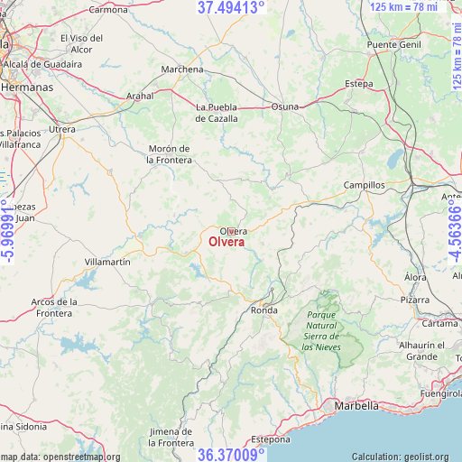
Olvera GPS coordinates[2]
36° 56' 3.048" North, 5° 16' 0.408" West
| Map corner | latitude | longitude |
|---|---|---|
| Upper-left | 37.49413°, | -5.96991° |
| Center: | 36.93418°, | -5.26678° |
| Lower-right: | 36.37009°, | -4.56366° |
| Map W x H: | 125×125 km | = 77.7×77.7mi |
| max Lat: | 43.74134° ⇑95.8% North |
| Olvera: | 36.93418° |
| min Lat: | ⇓4.2% South 27.64134° |
| min Long | Olvera | max Long |
| -18.00367° | -5.26678° | 4.2899° |
| W 24.1%⇐ | ⇒75.9% E |
Elevation
Elevation of Olvera is 590 m = 1936 ft, and this is 8 m = 26 ft below average elevation for this country.
| Max E: |
1682 m = 5518 ft | 55.4% |
| Avg. | 598 m = 1962 ft | |
| Olvera | 590 m = 1936 ft | |
Min E: |
0 m = 0 ft | 44.6% |
See also: Spain elevation on elevation.city.
Geographical zone
Olvera is located in North temperate zone (between Tropic of Cancer and the Arctic Circle). Distance of this Northern Tropic circle is 1500.8 km =932.6 mi to South.| Distance of | km | miles | from Olvera |
|---|---|---|---|
| North Pole | 5900.4 | 3666.3 | to North |
| Arctic Circle | 3294.5 | 2047.1 | to North |
| Tropic Cancer | 1500.8 | 932.6 | to South |
| Equator | 4106.7 | 2551.8 | to South |


Nearby cities:
15 places around Olvera: (largest is in red/bold)
• Alcalá del Valle
9 km =5.6 mi,  111°
111°
• Algodonales
13.7 km =8.5 mi,  244°
244°
• Algámitas
13.8 km =8.6 mi,  49°
49°
• Arriate
18.7 km =11.6 mi,  143°
143°
• Coripe
16 km =9.9 mi,  285°
285°
• Cuevas del Becerro
20.8 km =12.9 mi, 108°
• El Gastor
10.2 km =6.3 mi,  209°
209°
• El Saucejo
21.5 km =13.4 mi,  44°
44°
• Grazalema
21.4 km =13.3 mi, 205°
• Montecorto
13.5 km =8.4 mi,  191°
191°
• Pruna
5.8 km =3.6 mi, 43°
• Setenil de las Bodegas
10.9 km =6.8 mi, 135°
• Torre Alháquime
3.6 km =2.2 mi,  124°
124°
• Villanueva de San Juan
15.2 km =9.4 mi,  32°
32°
• Zahara
15.2 km =9.4 mi,  226°
226°
Sources, notices
• [Note1] Compared only with cities in Spain existing in our database
• [Src1] Map data: © OpenStreetMap contributors (CC-BY-SA)
• [Src2] Other city data from geonames.org with taken over terms of usage.
• [Src3] Geographical zone / Annual Mean Temperature by Robert A. Rohde @ Wikipedia
