Arriate geodata
Arriate (Andalusia) is a seat of a third-order administrative division; located in Spain in Europe/Madrid (GMT+2) time zone. With population of 3,821 people, there are 1510 cities with bigger population in this country. Compared to other cities in Spain, 96.8% of cities are located further ↑North; 74.2% of cities are located further →East and 55.1% of cities have higher elevation than Arriate. Note1


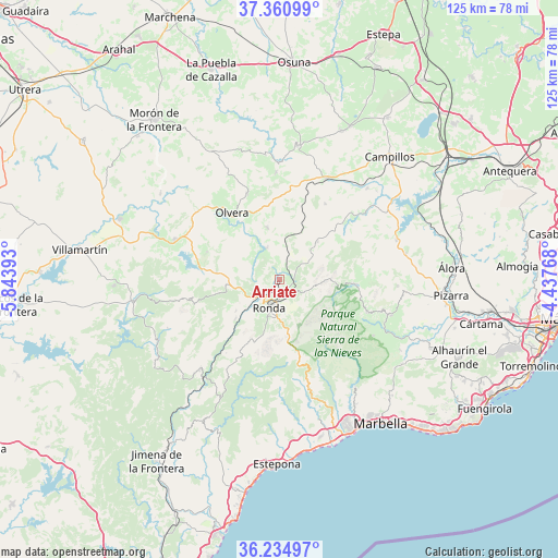
Arriate GPS coordinates[2]
36° 48' 0.18" North, 5° 8' 26.88" West
| Map corner | latitude | longitude |
|---|---|---|
| Upper-left | 37.36099°, | -5.84393° |
| Center: | 36.80005°, | -5.1408° |
| Lower-right: | 36.23497°, | -4.43768° |
| Map W x H: | 125.2×125.2 km | = 77.8×77.8mi |
| max Lat: | 43.74134° ⇑96.8% North |
| Arriate: | 36.80005° |
| min Lat: | ⇓3.2% South 27.64134° |
| min Long | Arriate | max Long |
| -18.00367° | -5.1408° | 4.2899° |
| W 25.8%⇐ | ⇒74.2% E |
Elevation
Elevation of Arriate is 594 m = 1949 ft, and this is 4 m = 13 ft below average elevation for this country.
| Max E: |
1682 m = 5518 ft | 55.1% |
| Avg. | 598 m = 1962 ft | |
| Arriate | 594 m = 1949 ft | |
Min E: |
0 m = 0 ft | 44.9% |
See also: Spain elevation on elevation.city.
Geographical zone
Arriate is located in North temperate zone (between Tropic of Cancer and the Arctic Circle). Distance of this Northern Tropic circle is 1485.9 km =923.3 mi to South.| Distance of | km | miles | from Arriate |
|---|---|---|---|
| North Pole | 5915.3 | 3675.6 | to North |
| Arctic Circle | 3309.4 | 2056.4 | to North |
| Tropic Cancer | 1485.9 | 923.3 | to South |
| Equator | 4091.8 | 2542.5 | to South |


Nearby cities:
15 places around Arriate: (largest is in red/bold)
• Alcalá del Valle
11.9 km =7.4 mi,  346°
346°
• Alpandeire
19.3 km =12 mi,  196°
196°
• Benaoján
13.4 km =8.3 mi,  227°
227°
• Cartajima
17.2 km =10.7 mi,  183°
183°
• Cuevas del Becerro
12 km =7.5 mi,  45°
45°
• El Gastor
17.3 km =10.7 mi,  290°
290°
• Igualeja
18.8 km =11.7 mi,  174°
174°
• Montecorto
14.1 km =8.8 mi,  277°
277°
• Montejaque
12 km =7.5 mi, 234°
• Olvera
18.7 km =11.6 mi,  323°
323°
• Parauta
16 km =9.9 mi, 176°
• Ronda
6.8 km =4.2 mi, 200°
• Serrato
17.1 km =10.6 mi,  56°
56°
• Setenil de las Bodegas
8 km =5 mi,  332°
332°
• Torre Alháquime
15.3 km =9.5 mi, 327°
Sources, notices
• [Note1] Compared only with cities in Spain existing in our database
• [Src1] Map data: © OpenStreetMap contributors (CC-BY-SA)
• [Src2] Other city data from geonames.org with taken over terms of usage.
• [Src3] Geographical zone / Annual Mean Temperature by Robert A. Rohde @ Wikipedia
