El Gastor geodata
El Gastor (Andalusia) is a populated place; located in Spain in Europe/Madrid (GMT+2) time zone. With population of 1,945 people, there are 2206 cities with bigger population in this country. Compared to other cities in Spain, 96.4% of cities are located further ↑North; 76.6% of cities are located further →East and 54.7% of cities have higher elevation than El Gastor. Note1


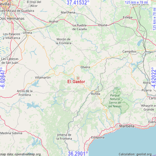
El Gastor GPS coordinates[2]
36° 51' 17.208" North, 5° 19' 24.024" West
| Map corner | latitude | longitude |
|---|---|---|
| Upper-left | 37.41532°, | -6.02647° |
| Center: | 36.85478°, | -5.32334° |
| Lower-right: | 36.2901°, | -4.62022° |
| Map W x H: | 125.1×125.1 km | = 77.7×77.7mi |
| max Lat: | 43.74134° ⇑96.4% North |
| El Gastor: | 36.85478° |
| min Lat: | ⇓3.6% South 27.64134° |
| min Long | El Gastor | max Long |
| -18.00367° | -5.32334° | 4.2899° |
| W 23.4%⇐ | ⇒76.6% E |
Elevation
Elevation of El Gastor is 599 m = 1965 ft, and this is 1 m = 3 ft above average elevation for this country.
| Max E: |
1682 m = 5518 ft | 54.7% |
| El Gastor | 599 m 1965 ft | |
| Avg. | 598 m = 1962 ft | |
Min E: |
0 m = 0 ft | 45.3% |
See also: Spain elevation on elevation.city.
Geographical zone
El Gastor is located in North temperate zone (between Tropic of Cancer and the Arctic Circle). Distance of this Northern Tropic circle is 1491.9 km =927 mi to South.| Distance of | km | miles | from El Gastor |
|---|---|---|---|
| North Pole | 5909.2 | 3671.8 | to North |
| Arctic Circle | 3303.3 | 2052.6 | to North |
| Tropic Cancer | 1491.9 | 927 | to South |
| Equator | 4097.9 | 2546.3 | to South |


Nearby cities:
15 places around El Gastor: (largest is in red/bold)
• Alcalá del Valle
14.5 km =9 mi,  67°
67°
• Algodonales
7.8 km =4.8 mi,  291°
291°
• Arriate
17.3 km =10.7 mi,  110°
110°
• Benaoján
16.3 km =10.1 mi,  157°
157°
• Coripe
16.8 km =10.4 mi,  321°
321°
• Grazalema
11.3 km =7 mi,  200°
200°
• Montecorto
4.9 km =3 mi,  152°
152°
• Montejaque
14.7 km =9.1 mi, 153°
• Olvera
10.2 km =6.3 mi,  29°
29°
• Pruna
15.9 km =9.9 mi, 34°
• Ronda
18.7 km =11.6 mi,  131°
131°
• Setenil de las Bodegas
12.6 km =7.8 mi,  85°
85°
• Torre Alháquime
10.5 km =6.5 mi,  49°
49°
• Villaluenga del Rosario
18.5 km =11.5 mi, 197°
• Zahara
6.2 km =3.9 mi,  255°
255°
Sources, notices
• [Note1] Compared only with cities in Spain existing in our database
• [Src1] Map data: © OpenStreetMap contributors (CC-BY-SA)
• [Src2] Other city data from geonames.org with taken over terms of usage.
• [Src3] Geographical zone / Annual Mean Temperature by Robert A. Rohde @ Wikipedia
