Alcalá del Valle geodata
Alcalá del Valle (Andalusia) is a seat of a third-order administrative division; located in Spain in Europe/Madrid (GMT+2) time zone. With population of 5,323 people, there are 1245 cities with bigger population in this country. Compared to other cities in Spain, 96.1% of cities are located further ↑North; 74.7% of cities are located further →East and 53.4% of cities have higher elevation than Alcalá del Valle. Note1
Administrative division(s):
- Level 1: Andalusia
- Level 2: Provincia de Cádiz
- Level 3: Alcalá del Valle


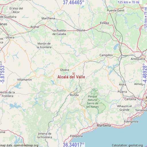
Alcalá del Valle GPS coordinates[2]
36° 54' 16.128" North, 5° 10' 20.64" West
| Map corner | latitude | longitude |
|---|---|---|
| Upper-left | 37.46465°, | -5.87553° |
| Center: | 36.90448°, | -5.1724° |
| Lower-right: | 36.34017°, | -4.46928° |
| Map W x H: | 125×125 km | = 77.7×77.7mi |
| max Lat: | 43.74134° ⇑96.1% North |
| Alcalá del Valle: | 36.90448° |
| min Lat: | ⇓3.9% South 27.64134° |
| min Long | Alcalá del Val | max Long |
| -18.00367° | -5.1724° | 4.2899° |
| W 25.3%⇐ | ⇒74.7% E |
Elevation
Elevation of Alcalá del Valle is 619 m = 2031 ft, and this is 21 m = 69 ft above average elevation for this country.
| Max E: |
1682 m = 5518 ft | 53.4% |
| Alcalá del Valle | 619 m 2031 ft | |
| Avg. | 598 m = 1962 ft | |
Min E: |
0 m = 0 ft | 46.6% |
See also: Spain elevation on elevation.city.
Geographical zone
Alcalá del Valle is located in North temperate zone (between Tropic of Cancer and the Arctic Circle). Distance of this Northern Tropic circle is 1497.5 km =930.5 mi to South.| Distance of | km | miles | from Alcalá del Valle |
|---|---|---|---|
| North Pole | 5903.7 | 3668.4 | to North |
| Arctic Circle | 3297.8 | 2049.2 | to North |
| Tropic Cancer | 1497.5 | 930.5 | to South |
| Equator | 4103.4 | 2549.7 | to South |


Nearby cities:
15 places around Alcalá del Valle: (largest is in red/bold)
• Algámitas
12.5 km =7.8 mi,  9°
9°
• Almargen
17.2 km =10.7 mi,  50°
50°
• Arriate
11.9 km =7.4 mi,  166°
166°
• Cañete la Real
14.2 km =8.8 mi,  68°
68°
• Cuevas del Becerro
11.8 km =7.3 mi,  105°
105°
• El Gastor
14.5 km =9 mi,  247°
247°
• El Saucejo
19.8 km =12.3 mi,  19°
19°
• Montecorto
14.9 km =9.3 mi,  228°
228°
• Olvera
9 km =5.6 mi,  291°
291°
• Pruna
8.7 km =5.4 mi,  329°
329°
• Ronda
18 km =11.2 mi,  178°
178°
• Serrato
17.1 km =10.6 mi,  97°
97°
• Setenil de las Bodegas
4.6 km =2.9 mi,  190°
190°
• Torre Alháquime
5.6 km =3.5 mi,  283°
283°
• Villanueva de San Juan
16.1 km =10 mi,  359°
359°
Sources, notices
• [Note1] Compared only with cities in Spain existing in our database
• [Src1] Map data: © OpenStreetMap contributors (CC-BY-SA)
• [Src2] Other city data from geonames.org with taken over terms of usage.
• [Src3] Geographical zone / Annual Mean Temperature by Robert A. Rohde @ Wikipedia
