Coripe geodata
Coripe (Andalusia) is a seat of a third-order administrative division; located in Spain in Europe/Madrid (GMT+2) time zone. With population of 1,411 people, there are 2535 cities with bigger population in this country. Compared to other cities in Spain, 95.6% of cities are located further ↑North; 77.9% of cities are located further →East and 73.2% of cities have higher elevation than Coripe. Note1


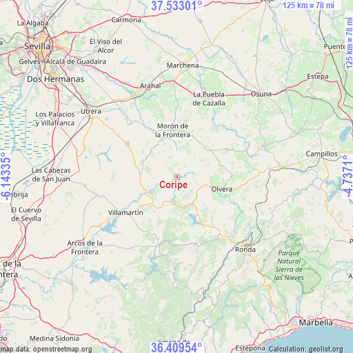
Coripe GPS coordinates[2]
36° 58' 24.06" North, 5° 26' 24.792" West
| Map corner | latitude | longitude |
|---|---|---|
| Upper-left | 37.53301°, | -6.14335° |
| Center: | 36.97335°, | -5.44022° |
| Lower-right: | 36.40954°, | -4.7371° |
| Map W x H: | 124.9×124.9 km | = 77.6×77.6mi |
| max Lat: | 43.74134° ⇑95.6% North |
| Coripe: | 36.97335° |
| min Lat: | ⇓4.4% South 27.64134° |
| min Long | Coripe | max Long |
| -18.00367° | -5.44022° | 4.2899° |
| W 22.1%⇐ | ⇒77.9% E |
Elevation
Elevation of Coripe is 328 m = 1076 ft, and this is 270 m = 886 ft below average elevation for this country.
| Max E: |
1682 m = 5518 ft | 73.2% |
| Avg. | 598 m = 1962 ft | |
| Coripe | 328 m = 1076 ft | |
Min E: |
0 m = 0 ft | 26.8% |
See also: Spain elevation on elevation.city.
Geographical zone
Coripe is located in North temperate zone (between Tropic of Cancer and the Arctic Circle). Distance of this Northern Tropic circle is 1505.1 km =935.2 mi to South.| Distance of | km | miles | from Coripe |
|---|---|---|---|
| North Pole | 5896 | 3663.6 | to North |
| Arctic Circle | 3290.1 | 2044.4 | to North |
| Tropic Cancer | 1505.1 | 935.2 | to South |
| Equator | 4111.1 | 2554.5 | to South |


Nearby cities:
15 places around Coripe: (largest is in red/bold)
• Algodonales
10.8 km =6.7 mi,  163°
163°
• El Bosque
24.6 km =15.3 mi,  193°
193°
• El Coronil
20.9 km =13 mi,  304°
304°
• El Gastor
16.8 km =10.4 mi,  141°
141°
• Grazalema
24.5 km =15.2 mi, 164°
• Montecorto
21.6 km =13.4 mi, 144°
• Montellano
11.9 km =7.4 mi,  281°
281°
• Morón de la Frontera
16.4 km =10.2 mi,  355°
355°
• Olvera
16 km =9.9 mi,  105°
105°
• Prado del Rey
23.1 km =14.4 mi,  206°
206°
• Pruna
19.4 km =12.1 mi,  90°
90°
• Puerto Serrano
10.8 km =6.7 mi,  238°
238°
• Torre Alháquime
19.4 km =12.1 mi, 109°
• Villamartín
22.1 km =13.7 mi, 235°
• Zahara
15.4 km =9.6 mi, 163°
Sources, notices
• [Note1] Compared only with cities in Spain existing in our database
• [Src1] Map data: © OpenStreetMap contributors (CC-BY-SA)
• [Src2] Other city data from geonames.org with taken over terms of usage.
• [Src3] Geographical zone / Annual Mean Temperature by Robert A. Rohde @ Wikipedia
