Pinoso geodata
Pinoso (Valencia) is a populated place; located in Spain in Europe/Madrid (GMT+2) time zone. With population of 7,090 people, there are 1026 cities with bigger population in this country. Compared to other cities in Spain, 86.1% of cities are located further ↑North; 76.8% of cities are located further ←West and 56.5% of cities have higher elevation than Pinoso. Note1
Administrative division(s):
- Level 1: Valencia
- Level 2: Provincia de Alicante
- Level 3: Pinós, el/Pinoso


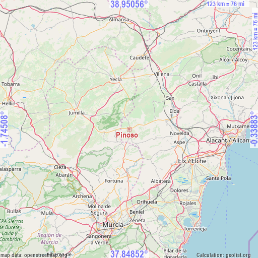
Pinoso GPS coordinates[2]
38° 24' 5.904" North, 1° 2' 31.056" West
| Map corner | latitude | longitude |
|---|---|---|
| Upper-left | 38.95056°, | -1.74508° |
| Center: | 38.40164°, | -1.04196° |
| Lower-right: | 37.84852°, | -0.33883° |
| Map W x H: | 122.5×122.5 km | = 76.1×76.1mi |
| max Lat: | 43.74134° ⇑86.1% North |
| Pinoso: | 38.40164° |
| min Lat: | ⇓13.9% South 27.64134° |
| min Long | Pinoso | max Long |
| -18.00367° | -1.04196° | 4.2899° |
| W 76.8%⇐ | ⇒23.2% E |
Elevation
Elevation of Pinoso is 573 m = 1880 ft, and this is 25 m = 82 ft below average elevation for this country.
| Max E: |
1682 m = 5518 ft | 56.5% |
| Avg. | 598 m = 1962 ft | |
| Pinoso | 573 m = 1880 ft | |
Min E: |
0 m = 0 ft | 43.5% |
See also: Spain elevation on elevation.city.
Geographical zone
Pinoso is located in North temperate zone (between Tropic of Cancer and the Arctic Circle). Distance of this Northern Tropic circle is 1663.9 km =1033.9 mi to South.| Distance of | km | miles | from Pinoso |
|---|---|---|---|
| North Pole | 5737.2 | 3564.9 | to North |
| Arctic Circle | 3131.3 | 1945.7 | to North |
| Tropic Cancer | 1663.9 | 1033.9 | to South |
| Equator | 4269.9 | 2653.2 | to South |


Nearby cities:
15 places around Pinoso: (largest is in red/bold)
• Abanilla
21.8 km =13.5 mi,  179°
179°
• Algueña
7.7 km =4.8 mi,  154°
154°
• Aspe
24.8 km =15.4 mi,  104°
104°
• Crevillente
26.4 km =16.4 mi,  129°
129°
• Elda
23.4 km =14.5 mi,  68°
68°
• Fortuna
25.6 km =15.9 mi,  196°
196°
• Hondón de las Nieves
19.4 km =12.1 mi,  122°
122°
• Hondón de los Frailes
17.3 km =10.7 mi, 145°
• Jumilla
26.1 km =16.2 mi,  289°
289°
• La Romana
13.1 km =8.1 mi,  106°
106°
• Monóvar
18 km =11.2 mi,  76°
76°
• Novelda
24 km =14.9 mi,  94°
94°
• Salinas
17.4 km =10.8 mi,  40°
40°
• Sax
24.7 km =15.3 mi,  52°
52°
• Yecla
24.4 km =15.2 mi,  344°
344°
Sources, notices
• [Note1] Compared only with cities in Spain existing in our database
• [Src1] Map data: © OpenStreetMap contributors (CC-BY-SA)
• [Src2] Other city data from geonames.org with taken over terms of usage.
• [Src3] Geographical zone / Annual Mean Temperature by Robert A. Rohde @ Wikipedia
