Abanilla geodata
Abanilla (Murcia) is a seat of a third-order administrative division; located in Spain in Europe/Madrid (GMT+2) time zone. With population of 6,079 people, there are 1128 cities with bigger population in this country. Compared to other cities in Spain, 87.2% of cities are located further ↑North; 76.9% of cities are located further ←West and 80.8% of cities have higher elevation than Abanilla. Note1


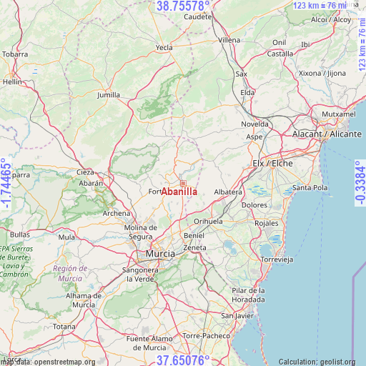
Abanilla GPS coordinates[2]
38° 12' 19.332" North, 1° 2' 29.508" West
| Map corner | latitude | longitude |
|---|---|---|
| Upper-left | 38.75578°, | -1.74465° |
| Center: | 38.20537°, | -1.04153° |
| Lower-right: | 37.65076°, | -0.3384° |
| Map W x H: | 122.9×122.9 km | = 76.4×76.4mi |
| max Lat: | 43.74134° ⇑87.2% North |
| Abanilla: | 38.20537° |
| min Lat: | ⇓12.8% South 27.64134° |
| min Long | Abanilla | max Long |
| -18.00367° | -1.04153° | 4.2899° |
| W 76.9%⇐ | ⇒23.1% E |
Elevation
Elevation of Abanilla is 207 m = 679 ft, and this is 391 m = 1283 ft below average elevation for this country.
| Max E: |
1682 m = 5518 ft | 80.8% |
| Avg. | 598 m = 1962 ft | |
| Abanilla | 207 m = 679 ft | |
Min E: |
0 m = 0 ft | 19.2% |
See also: Spain elevation on elevation.city.
Geographical zone
Abanilla is located in North temperate zone (between Tropic of Cancer and the Arctic Circle). Distance of this Northern Tropic circle is 1642.1 km =1020.4 mi to South.| Distance of | km | miles | from Abanilla |
|---|---|---|---|
| North Pole | 5759 | 3578.5 | to North |
| Arctic Circle | 3153.1 | 1959.2 | to North |
| Tropic Cancer | 1642.1 | 1020.4 | to South |
| Equator | 4248 | 2639.6 | to South |


Nearby cities:
15 places around Abanilla: (largest is in red/bold)
• Albatera
15.2 km =9.4 mi,  101°
101°
• Algueña
15.2 km =9.4 mi,  12°
12°
• Benferri
9.9 km =6.2 mi,  135°
135°
• Beniel
18 km =11.2 mi,  169°
169°
• Callosa de Segura
16.8 km =10.4 mi,  122°
122°
• Cobatillas
17 km =10.6 mi,  190°
190°
• Cox
15.2 km =9.4 mi, 117°
• Esparragal
19.5 km =12.1 mi, 190°
• Fortuna
7.8 km =4.8 mi,  250°
250°
• Granja de Rocamora
14.4 km =8.9 mi,  114°
114°
• Hondón de los Frailes
12.4 km =7.7 mi,  52°
52°
• Orihuela
15.9 km =9.9 mi,  147°
147°
• Redován
15.2 km =9.4 mi,  130°
130°
• San Isidro
18.1 km =11.2 mi, 101°
• Santomera
16 km =9.9 mi,  182°
182°
Sources, notices
• [Note1] Compared only with cities in Spain existing in our database
• [Src1] Map data: © OpenStreetMap contributors (CC-BY-SA)
• [Src2] Other city data from geonames.org with taken over terms of usage.
• [Src3] Geographical zone / Annual Mean Temperature by Robert A. Rohde @ Wikipedia
