Salinas geodata
Salinas (Valencia) is a seat of a third-order administrative division; located in Spain in Europe/Madrid (GMT+2) time zone. With population of 1,422 people, there are 2531 cities with bigger population in this country. Compared to other cities in Spain, 85.5% of cities are located further ↑North; 77.9% of cities are located further ←West and 62.6% of cities have higher elevation than Salinas. Note1


Salinas GPS coordinates[2]
38° 31' 12.9" North, 0° 54' 43.272" West
| Map corner | latitude | longitude |
|---|---|---|
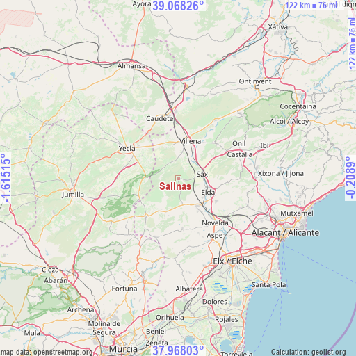
| Upper-left | 39.06826°, | -1.61515° |
| Center: | 38.52025°, | -0.91202° |
| Lower-right: | 37.96803°, | -0.2089° |
| Map W x H: | 122.3×122.3 km | = 76×76mi |
| max Lat: | 43.74134° ⇑85.5% North |
| Salinas: | 38.52025° |
| min Lat: | ⇓14.5% South 27.64134° |
| min Long | Salinas | max Long |
| -18.00367° | -0.91202° | 4.2899° |
| W 77.9%⇐ | ⇒22.1% E |
Elevation
Elevation of Salinas is 491 m = 1611 ft, and this is 107 m = 351 ft below average elevation for this country.
| Max E: |
1682 m = 5518 ft | 62.6% |
| Avg. | 598 m = 1962 ft | |
| Salinas | 491 m = 1611 ft | |
Min E: |
0 m = 0 ft | 37.4% |
See also: Spain elevation on elevation.city.
Geographical zone
Salinas is located in North temperate zone (between Tropic of Cancer and the Arctic Circle). Distance of this Northern Tropic circle is 1677.1 km =1042.1 mi to South.| Distance of | km | miles | from Salinas |
|---|---|---|---|
| North Pole | 5724 | 3556.7 | to North |
| Arctic Circle | 3118.1 | 1937.5 | to North |
| Tropic Cancer | 1677.1 | 1042.1 | to South |
| Equator | 4283.1 | 2661.4 | to South |


Nearby cities:
15 places around Salinas: (largest is in red/bold)
• Algueña
21.7 km =13.5 mi,  201°
201°
• Aspe
23.2 km =14.4 mi,  147°
147°
• Biar
17.8 km =11.1 mi,  46°
46°
• Castalla
22.5 km =14 mi,  67°
67°
• Caudete
21.7 km =13.5 mi,  342°
342°
• Cañada
19.1 km =11.9 mi,  26°
26°
• Elda
11.5 km =7.1 mi,  114°
114°
• La Romana
17 km =10.6 mi,  176°
176°
• Monforte del Cid
22.3 km =13.9 mi,  134°
134°
• Monóvar
11 km =6.8 mi, 145°
• Novelda
19.6 km =12.2 mi,  140°
140°
• Pinoso
17.4 km =10.8 mi,  220°
220°
• Sax
8.4 km =5.2 mi,  76°
76°
• Villena
13.6 km =8.5 mi,  17°
17°
• Yecla
20.5 km =12.7 mi,  300°
300°
Sources, notices
• [Note1] Compared only with cities in Spain existing in our database
• [Src1] Map data: © OpenStreetMap contributors (CC-BY-SA)
• [Src2] Other city data from geonames.org with taken over terms of usage.
• [Src3] Geographical zone / Annual Mean Temperature by Robert A. Rohde @ Wikipedia
