Écija geodata
Écija (Andalusia) is a seat of a third-order administrative division; located in Spain in Europe/Madrid (GMT+2) time zone. With population of 40,400 people, there are 219 cities with bigger population in this country. Compared to other cities in Spain, 91.1% of cities are located further ↑North; 73.5% of cities are located further →East and 87.3% of cities have higher elevation than Écija. Note1


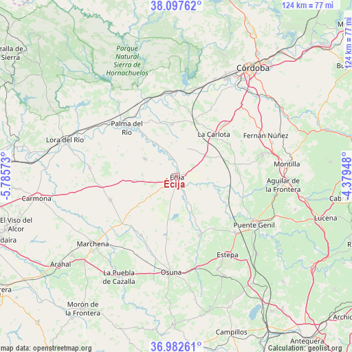
Écija GPS coordinates[2]
37° 32' 31.92" North, 5° 4' 57.36" West
| Map corner | latitude | longitude |
|---|---|---|
| Upper-left | 38.09762°, | -5.78573° |
| Center: | 37.5422°, | -5.0826° |
| Lower-right: | 36.98261°, | -4.37948° |
| Map W x H: | 124×124 km | = 77.1×77.1mi |
| max Lat: | 43.74134° ⇑91.1% North |
| Écija: | 37.5422° |
| min Lat: | ⇓8.9% South 27.64134° |
| min Long | Écija | max Long |
| -18.00367° | -5.0826° | 4.2899° |
| W 26.5%⇐ | ⇒73.5% E |
Elevation
Elevation of Écija is 105 m = 344 ft, and this is 493 m = 1617 ft below average elevation for this country.
| Max E: |
1682 m = 5518 ft | 87.3% |
| Avg. | 598 m = 1962 ft | |
| Écija | 105 m = 344 ft | |
Min E: |
0 m = 0 ft | 12.7% |
See also: Écija elevation on elevation.city.
Geographical zone
Écija is located in North temperate zone (between Tropic of Cancer and the Arctic Circle). Distance of this Northern Tropic circle is 1568.4 km =974.6 mi to South.| Distance of | km | miles | from Écija |
|---|---|---|---|
| North Pole | 5832.8 | 3624.3 | to North |
| Arctic Circle | 3226.9 | 2005.1 | to North |
| Tropic Cancer | 1568.4 | 974.6 | to South |
| Equator | 4174.3 | 2593.8 | to South |


Nearby cities:
15 places around Écija: (largest is in red/bold)
• Cañada Rosal
12.9 km =8 mi,  299°
299°
• El Rubio
22.3 km =13.9 mi,  158°
158°
• Fuente Palmera
18.2 km =11.3 mi,  355°
355°
• Fuentes de Andalucía
24.8 km =15.4 mi,  249°
249°
• Guadalcázar
26.9 km =16.7 mi,  27°
27°
• Herrera
28.5 km =17.7 mi,  133°
133°
• La Carlota
19.8 km =12.3 mi,  42°
42°
• La Lantejuela
24.4 km =15.2 mi,  210°
210°
• La Luisiana
14.8 km =9.2 mi,  263°
263°
• La Victoria
25.5 km =15.8 mi,  52°
52°
• Marinaleda
21.9 km =13.6 mi,  150°
150°
• Palma del Río
24.8 km =15.4 mi,  315°
315°
• Posadas
29 km =18 mi, 355°
• San Sebastián de los Ballesteros
25.9 km =16.1 mi,  61°
61°
• Santaella
21.2 km =13.2 mi,  83°
83°
Sources, notices
• [Note1] Compared only with cities in Spain existing in our database
• [Src1] Map data: © OpenStreetMap contributors (CC-BY-SA)
• [Src2] Other city data from geonames.org with taken over terms of usage.
• [Src3] Geographical zone / Annual Mean Temperature by Robert A. Rohde @ Wikipedia
