La Luisiana geodata
La Luisiana (Andalusia) is a populated place; located in Spain in Europe/Madrid (GMT+2) time zone. With population of 4,434 people, there are 1395 cities with bigger population in this country. Compared to other cities in Spain, 91.2% of cities are located further ↑North; 75.7% of cities are located further →East and 82.8% of cities have higher elevation than La Luisiana. Note1


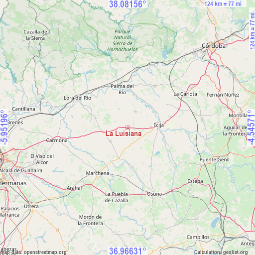
La Luisiana GPS coordinates[2]
37° 31' 33.672" North, 5° 14' 55.788" West
| Map corner | latitude | longitude |
|---|---|---|
| Upper-left | 38.08156°, | -5.95196° |
| Center: | 37.52602°, | -5.24883° |
| Lower-right: | 36.96631°, | -4.54571° |
| Map W x H: | 124×124 km | = 77.1×77.1mi |
| max Lat: | 43.74134° ⇑91.2% North |
| La Luisiana: | 37.52602° |
| min Lat: | ⇓8.8% South 27.64134° |
| min Long | La Luisiana | max Long |
| -18.00367° | -5.24883° | 4.2899° |
| W 24.3%⇐ | ⇒75.7% E |
Elevation
Elevation of La Luisiana is 171 m = 561 ft, and this is 427 m = 1401 ft below average elevation for this country.
| Max E: |
1682 m = 5518 ft | 82.8% |
| Avg. | 598 m = 1962 ft | |
| La Luisiana | 171 m = 561 ft | |
Min E: |
0 m = 0 ft | 17.2% |
See also: Spain elevation on elevation.city.
Geographical zone
La Luisiana is located in North temperate zone (between Tropic of Cancer and the Arctic Circle). Distance of this Northern Tropic circle is 1566.6 km =973.4 mi to South.| Distance of | km | miles | from La Luisiana |
|---|---|---|---|
| North Pole | 5834.6 | 3625.5 | to North |
| Arctic Circle | 3228.7 | 2006.2 | to North |
| Tropic Cancer | 1566.6 | 973.4 | to South |
| Equator | 4172.5 | 2592.7 | to South |


Nearby cities:
15 places around La Luisiana: (largest is in red/bold)
• Cañada Rosal
8.8 km =5.5 mi,  22°
22°
• El Rubio
29.7 km =18.5 mi,  129°
129°
• Fuente Palmera
23.8 km =14.8 mi,  33°
33°
• Fuentes de Andalucía
11 km =6.8 mi,  231°
231°
• La Campana
16.4 km =10.2 mi,  286°
286°
• La Carlota
32.4 km =20.1 mi,  59°
59°
• La Lantejuela
19.3 km =12 mi,  173°
173°
• La Puebla de los Infantes
30.9 km =19.2 mi,  336°
336°
• Lora del Río
28.7 km =17.8 mi,  301°
301°
• Marchena
26.5 km =16.5 mi,  214°
214°
• Marinaleda
30.8 km =19.1 mi,  123°
123°
• Palma del Río
19.6 km =12.2 mi,  351°
351°
• Peñaflor
22 km =13.7 mi, 337°
• Posadas
33.1 km =20.6 mi, 22°
• Écija
14.8 km =9.2 mi,  83°
83°
Sources, notices
• [Note1] Compared only with cities in Spain existing in our database
• [Src1] Map data: © OpenStreetMap contributors (CC-BY-SA)
• [Src2] Other city data from geonames.org with taken over terms of usage.
• [Src3] Geographical zone / Annual Mean Temperature by Robert A. Rohde @ Wikipedia
