Dúrcal geodata
Dúrcal (Andalusia) is a seat of a third-order administrative division; located in Spain in Europe/Madrid (GMT+2) time zone. With population of 6,913 people, there are 1045 cities with bigger population in this country. Compared to other cities in Spain, 95.4% of cities are located further ↑North; 53.1% of cities are located further →East and 66.6% of cities have lower elevation than Dúrcal. Note1


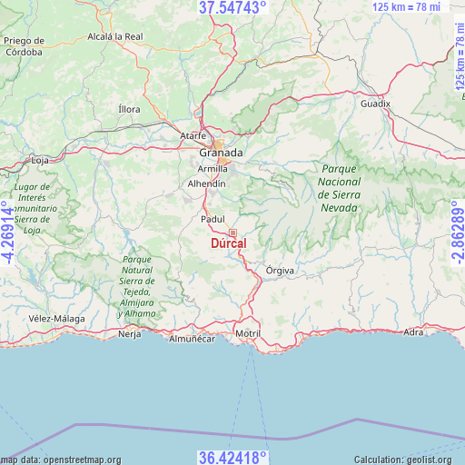
Dúrcal GPS coordinates[2]
36° 59' 16.368" North, 3° 33' 57.636" West
| Map corner | latitude | longitude |
|---|---|---|
| Upper-left | 37.54743°, | -4.26914° |
| Center: | 36.98788°, | -3.56601° |
| Lower-right: | 36.42418°, | -2.86289° |
| Map W x H: | 124.9×124.9 km | = 77.6×77.6mi |
| max Lat: | 43.74134° ⇑95.4% North |
| Dúrcal: | 36.98788° |
| min Lat: | ⇓4.6% South 27.64134° |
| min Long | Dúrcal | max Long |
| -18.00367° | -3.56601° | 4.2899° |
| W 46.9%⇐ | ⇒53.1% E |
Elevation
Elevation of Dúrcal is 789 m = 2589 ft, and this is 191 m = 627 ft above average elevation for this country.
| Max E: |
1682 m = 5518 ft | 33.4% |
| Dúrcal | 789 m 2589 ft | |
| Avg. | 598 m = 1962 ft | |
Min E: |
0 m = 0 ft | 66.6% |
See also: Spain elevation on elevation.city.
Geographical zone
Dúrcal is located in North temperate zone (between Tropic of Cancer and the Arctic Circle). Distance of this Northern Tropic circle is 1506.7 km =936.2 mi to South.| Distance of | km | miles | from Dúrcal |
|---|---|---|---|
| North Pole | 5894.4 | 3662.6 | to North |
| Arctic Circle | 3288.5 | 2043.4 | to North |
| Tropic Cancer | 1506.7 | 936.2 | to South |
| Equator | 4112.7 | 2555.5 | to South |


Nearby cities:
15 places around Dúrcal: (largest is in red/bold)
• Albuñuelas
8.8 km =5.5 mi,  221°
221°
• Alhendín
15.2 km =9.4 mi,  332°
332°
• Carataunas
15.8 km =9.8 mi,  117°
117°
• Cájar
16.2 km =10.1 mi,  357°
357°
• Cáñar
14 km =8.7 mi, 118°
• Dílar
10 km =6.2 mi,  341°
341°
• Gójar
13.4 km =8.3 mi, 344°
• Lanjarón
10.7 km =6.6 mi,  135°
135°
• Nigüelas
2.6 km =1.6 mi, 115°
• Ogíjares
15.1 km =9.4 mi,  345°
345°
• Otura
12.7 km =7.9 mi, 331°
• Padul
6.8 km =4.2 mi,  307°
307°
• Soportújar
15.7 km =9.8 mi,  114°
114°
• Zubia
14.7 km =9.1 mi, 353°
• Órgiva
15.8 km =9.8 mi,  126°
126°
Sources, notices
• [Note1] Compared only with cities in Spain existing in our database
• [Src1] Map data: © OpenStreetMap contributors (CC-BY-SA)
• [Src2] Other city data from geonames.org with taken over terms of usage.
• [Src3] Geographical zone / Annual Mean Temperature by Robert A. Rohde @ Wikipedia
