Alcúdia geodata
Alcúdia (Balearic Islands) is a seat of a third-order administrative division; located in Spain in Europe/Madrid (GMT+2) time zone. With population of 19,071 people, there are 495 cities with bigger population in this country. Compared to other cities in Spain, 72.2% of cities are located further ↑North; 99.5% of cities are located further ←West and 96.2% of cities have higher elevation than Alcúdia. Note1


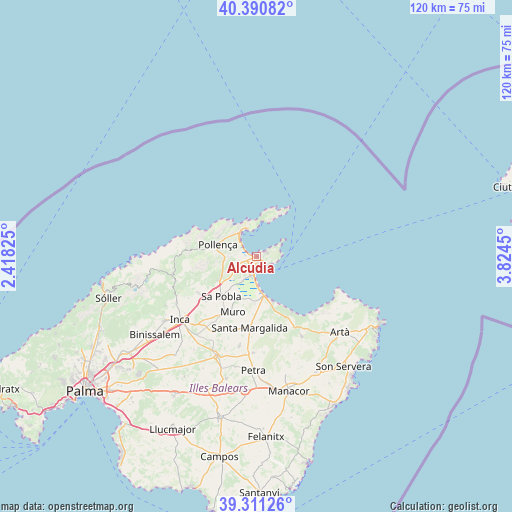
Alcúdia GPS coordinates[2]
39° 51' 11.376" North, 3° 7' 16.968" East
| Map corner | latitude | longitude |
|---|---|---|
| Upper-left | 40.39082°, | 2.41825° |
| Center: | 39.85316°, | 3.12138° |
| Lower-right: | 39.31126°, | 3.8245° |
| Map W x H: | 120×120 km | = 74.6×74.6mi |
| max Lat: | 43.74134° ⇑72.2% North |
| Alcúdia: | 39.85316° |
| min Lat: | ⇓27.8% South 27.64134° |
| min Long | Alcúdia | max Long |
| -18.00367° | 3.12138° | 4.2899° |
| W 99.5%⇐ | ⇒0.5% E |
Elevation
Elevation of Alcúdia is 19 m = 62 ft, and this is 579 m = 1900 ft below average elevation for this country.
| Max E: |
1682 m = 5518 ft | 96.2% |
| Avg. | 598 m = 1962 ft | |
| Alcúdia | 19 m = 62 ft | |
Min E: |
0 m = 0 ft | 3.8% |
See also: Spain elevation on elevation.city.
Geographical zone
Alcúdia is located in North temperate zone (between Tropic of Cancer and the Arctic Circle). Distance of this Northern Tropic circle is 1825.3 km =1134.2 mi to South.| Distance of | km | miles | from Alcúdia |
|---|---|---|---|
| North Pole | 5575.8 | 3464.6 | to North |
| Arctic Circle | 2969.9 | 1845.4 | to North |
| Tropic Cancer | 1825.3 | 1134.2 | to South |
| Equator | 4431.3 | 2753.5 | to South |


Nearby cities:
15 places around Alcúdia: (largest is in red/bold)
• Ariany
22.6 km =14 mi,  182°
182°
• Búger
15.8 km =9.8 mi,  228°
228°
• Campanet
15.9 km =9.9 mi,  236°
236°
• Can Picafort
10.1 km =6.3 mi,  163°
163°
• Escorca
21.8 km =13.5 mi,  260°
260°
• Inca
23.2 km =14.4 mi, 230°
• Llubí
19.7 km =12.2 mi,  209°
209°
• Maria de la Salut
21.5 km =13.4 mi,  191°
191°
• Muro
14.1 km =8.8 mi,  203°
203°
• Pollença
9.3 km =5.8 mi,  286°
286°
• Port d'Alcúdia
1.6 km =1 mi,  142°
142°
• Port de Pollença
6.9 km =4.3 mi,  330°
330°
• Santa Margalida
17 km =10.6 mi, 185°
• Selva
21.8 km =13.5 mi, 239°
• sa Pobla
12.5 km =7.8 mi,  221°
221°
Sources, notices
• [Note1] Compared only with cities in Spain existing in our database
• [Src1] Map data: © OpenStreetMap contributors (CC-BY-SA)
• [Src2] Other city data from geonames.org with taken over terms of usage.
• [Src3] Geographical zone / Annual Mean Temperature by Robert A. Rohde @ Wikipedia
