Los Villares geodata
Los Villares (Andalusia) is a populated place; located in Spain in Europe/Madrid (GMT+2) time zone. With population of 5,289 people, there are 1250 cities with bigger population in this country. Compared to other cities in Spain, 90.2% of cities are located further ↑North; 57.1% of cities are located further →East and 53.6% of cities have higher elevation than Los Villares. Note1


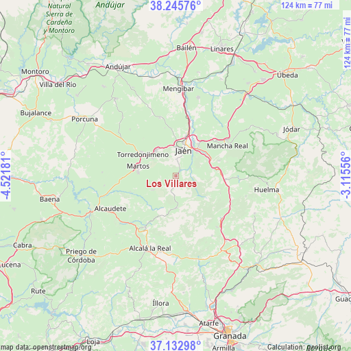
Los Villares GPS coordinates[2]
37° 41' 29.256" North, 3° 49' 7.248" West
| Map corner | latitude | longitude |
|---|---|---|
| Upper-left | 38.24576°, | -4.52181° |
| Center: | 37.69146°, | -3.81868° |
| Lower-right: | 37.13298°, | -3.11556° |
| Map W x H: | 123.7×123.7 km | = 76.9×76.9mi |
| max Lat: | 43.74134° ⇑90.2% North |
| Los Villares: | 37.69146° |
| min Lat: | ⇓9.8% South 27.64134° |
| min Long | Los Villares | max Long |
| -18.00367° | -3.81868° | 4.2899° |
| W 42.9%⇐ | ⇒57.1% E |
Elevation
Elevation of Los Villares is 617 m = 2024 ft, and this is 19 m = 62 ft above average elevation for this country.
| Max E: |
1682 m = 5518 ft | 53.6% |
| Los Villares | 617 m 2024 ft | |
| Avg. | 598 m = 1962 ft | |
Min E: |
0 m = 0 ft | 46.4% |
See also: Spain elevation on elevation.city.
Geographical zone
Los Villares is located in North temperate zone (between Tropic of Cancer and the Arctic Circle). Distance of this Northern Tropic circle is 1585 km =984.9 mi to South.| Distance of | km | miles | from Los Villares |
|---|---|---|---|
| North Pole | 5816.2 | 3614 | to North |
| Arctic Circle | 3210.3 | 1994.8 | to North |
| Tropic Cancer | 1585 | 984.9 | to South |
| Equator | 4190.9 | 2604.1 | to South |


Nearby cities:
15 places around Los Villares: (largest is in red/bold)
• Cambil
22.3 km =13.9 mi,  93°
93°
• Campillo de Arenas
22.1 km =13.7 mi,  133°
133°
• Castillo de Locubín
21.1 km =13.1 mi,  210°
210°
• Fuensanta de Martos
9.3 km =5.8 mi,  238°
238°
• Fuerte del Rey
21.2 km =13.2 mi,  344°
344°
• Jamilena
10.4 km =6.5 mi,  306°
306°
• Jaén
9 km =5.6 mi,  16°
16°
• La Guardia de Jaén
12.4 km =7.7 mi,  62°
62°
• Mancha Real
21 km =13 mi, 59°
• Martos
13.9 km =8.6 mi,  283°
283°
• Pegalajar
15.8 km =9.8 mi,  70°
70°
• Torre del Campo
11.2 km =7 mi,  321°
321°
• Torredonjimeno
14.9 km =9.3 mi,  304°
304°
• Valdepeñas de Jaén
11.4 km =7.1 mi,  178°
178°
• Villardompardo
22.8 km =14.2 mi, 315°
Sources, notices
• [Note1] Compared only with cities in Spain existing in our database
• [Src1] Map data: © OpenStreetMap contributors (CC-BY-SA)
• [Src2] Other city data from geonames.org with taken over terms of usage.
• [Src3] Geographical zone / Annual Mean Temperature by Robert A. Rohde @ Wikipedia
