Mancha Real geodata
Mancha Real (Andalusia) is a seat of a third-order administrative division; located in Spain in Europe/Madrid (GMT+2) time zone. With population of 10,972 people, there are 804 cities with bigger population in this country. Compared to other cities in Spain, 89.6% of cities are located further ↑North; 53.9% of cities are located further →East and 61.9% of cities have lower elevation than Mancha Real. Note1


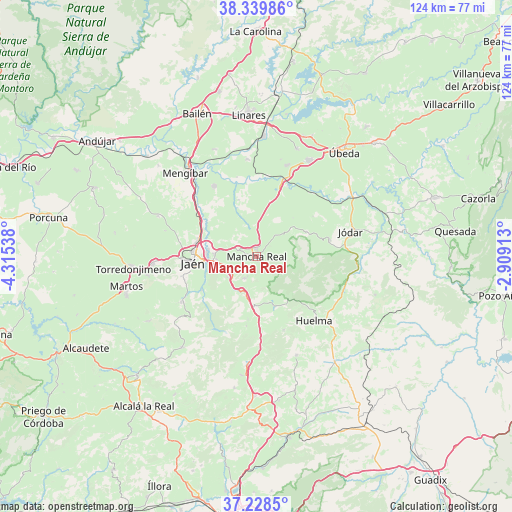
Mancha Real GPS coordinates[2]
37° 47' 10.572" North, 3° 36' 44.136" West
| Map corner | latitude | longitude |
|---|---|---|
| Upper-left | 38.33986°, | -4.31538° |
| Center: | 37.78627°, | -3.61226° |
| Lower-right: | 37.2285°, | -2.90913° |
| Map W x H: | 123.6×123.6 km | = 76.8×76.8mi |
| max Lat: | 43.74134° ⇑89.6% North |
| Mancha Real: | 37.78627° |
| min Lat: | ⇓10.4% South 27.64134° |
| min Long | Mancha Real | max Long |
| -18.00367° | -3.61226° | 4.2899° |
| W 46.1%⇐ | ⇒53.9% E |
Elevation
Elevation of Mancha Real is 756 m = 2480 ft, and this is 158 m = 518 ft above average elevation for this country.
| Max E: |
1682 m = 5518 ft | 38.1% |
| Mancha Real | 756 m 2480 ft | |
| Avg. | 598 m = 1962 ft | |
Min E: |
0 m = 0 ft | 61.9% |
See also: Spain elevation on elevation.city.
Geographical zone
Mancha Real is located in North temperate zone (between Tropic of Cancer and the Arctic Circle). Distance of this Northern Tropic circle is 1595.5 km =991.4 mi to South.| Distance of | km | miles | from Mancha Real |
|---|---|---|---|
| North Pole | 5805.6 | 3607.4 | to North |
| Arctic Circle | 3199.7 | 1988.2 | to North |
| Tropic Cancer | 1595.5 | 991.4 | to South |
| Equator | 4201.4 | 2610.6 | to South |


Nearby cities:
15 places around Mancha Real: (largest is in red/bold)
• Begíjar
23.2 km =14.4 mi,  17°
17°
• Bélmez de la Moraleda
21.4 km =13.3 mi,  108°
108°
• Cambil
12.6 km =7.8 mi,  160°
160°
• Huelma
20.4 km =12.7 mi,  138°
138°
• Jaén
15.8 km =9.8 mi,  263°
263°
• Jimena
13.4 km =8.3 mi,  62°
62°
• Jódar
23.6 km =14.7 mi,  75°
75°
• La Guardia de Jaén
8.6 km =5.3 mi,  235°
235°
• Los Villares
21 km =13 mi, 239°
• Lupión
24.1 km =15 mi,  13°
13°
• Montejicar
25.6 km =15.9 mi, 158°
• Pegalajar
6.1 km =3.8 mi,  212°
212°
• Torre del Campo
25.1 km =15.6 mi,  265°
265°
• Torreblascopedro
23.6 km =14.7 mi,  354°
354°
• Torres
9.1 km =5.7 mi,  90°
90°
Sources, notices
• [Note1] Compared only with cities in Spain existing in our database
• [Src1] Map data: © OpenStreetMap contributors (CC-BY-SA)
• [Src2] Other city data from geonames.org with taken over terms of usage.
• [Src3] Geographical zone / Annual Mean Temperature by Robert A. Rohde @ Wikipedia
