Castillo de Locubín geodata
Castillo de Locubín (Andalusia) is a seat of a third-order administrative division; located in Spain in Europe/Madrid (GMT+2) time zone. With population of 5,052 people, there are 1292 cities with bigger population in this country. Compared to other cities in Spain, 91.2% of cities are located further ↑North; 58.9% of cities are located further →East and 57.6% of cities have lower elevation than Castillo de Locubín. Note1
Administrative division(s):
- Level 1: Andalusia
- Level 2: Provincia de Jaén
- Level 3: Castillo de Locubín


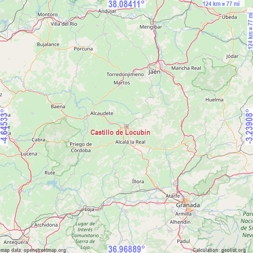
Castillo de Locubín GPS coordinates[2]
37° 31' 42.888" North, 3° 56' 31.92" West
| Map corner | latitude | longitude |
|---|---|---|
| Upper-left | 38.08411°, | -4.64533° |
| Center: | 37.52858°, | -3.9422° |
| Lower-right: | 36.96889°, | -3.23908° |
| Map W x H: | 124×124 km | = 77.1×77.1mi |
| max Lat: | 43.74134° ⇑91.2% North |
| Castillo de Locubín: | 37.52858° |
| min Lat: | ⇓8.8% South 27.64134° |
| min Long | Castillo de Loc | max Long |
| -18.00367° | -3.9422° | 4.2899° |
| W 41.1%⇐ | ⇒58.9% E |
Elevation
Elevation of Castillo de Locubín is 727 m = 2385 ft, and this is 129 m = 423 ft above average elevation for this country.
| Max E: |
1682 m = 5518 ft | 42.4% |
| Castillo de Locubín | 727 m 2385 ft | |
| Avg. | 598 m = 1962 ft | |
Min E: |
0 m = 0 ft | 57.6% |
See also: Spain elevation on elevation.city.
Geographical zone
Castillo de Locubín is located in North temperate zone (between Tropic of Cancer and the Arctic Circle). Distance of this Northern Tropic circle is 1566.9 km =973.6 mi to South.| Distance of | km | miles | from Castillo de Locubín |
|---|---|---|---|
| North Pole | 5834.3 | 3625.3 | to North |
| Arctic Circle | 3228.4 | 2006 | to North |
| Tropic Cancer | 1566.9 | 973.6 | to South |
| Equator | 4172.8 | 2592.9 | to South |


Nearby cities:
15 places around Castillo de Locubín: (largest is in red/bold)
• Alcalá la Real
7.7 km =4.8 mi,  167°
167°
• Alcaudete
14.2 km =8.8 mi,  299°
299°
• Almedinilla
16.4 km =10.2 mi,  232°
232°
• Frailes
10.4 km =6.5 mi,  117°
117°
• Fuensanta de Martos
13.6 km =8.5 mi,  12°
12°
• Fuente-Tójar
18.1 km =11.2 mi,  263°
263°
• Jamilena
24.4 km =15.2 mi, 5°
• Los Villares
21.1 km =13.1 mi,  30°
30°
• Martos
21.6 km =13.4 mi,  352°
352°
• Moclín
25.1 km =15.6 mi,  146°
146°
• Montefrío
23.6 km =14.7 mi,  194°
194°
• Montillana
23.9 km =14.9 mi,  97°
97°
• Noalejo
25.2 km =15.7 mi,  89°
89°
• Priego de Córdoba
24.5 km =15.2 mi,  245°
245°
• Valdepeñas de Jaén
13.1 km =8.1 mi,  59°
59°
Sources, notices
• [Note1] Compared only with cities in Spain existing in our database
• [Src1] Map data: © OpenStreetMap contributors (CC-BY-SA)
• [Src2] Other city data from geonames.org with taken over terms of usage.
• [Src3] Geographical zone / Annual Mean Temperature by Robert A. Rohde @ Wikipedia
