Jaén geodata
Jaén (Andalusia) is a seat of a second-order administrative division; located in Spain in Europe/Madrid (GMT+2) time zone. With population of 116,557 people, there are 78 cities with bigger population in this country. Compared to other cities in Spain, 89.7% of cities are located further ↑North; 56.6% of cities are located further →East and 57.4% of cities have higher elevation than Jaén. Note1


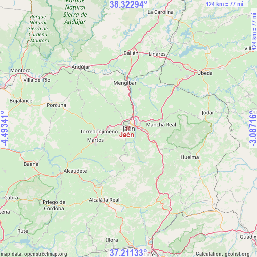
Jaén GPS coordinates[2]
37° 46' 9.192" North, 3° 47' 25.008" West
| Map corner | latitude | longitude |
|---|---|---|
| Upper-left | 38.32294°, | -4.49341° |
| Center: | 37.76922°, | -3.79028° |
| Lower-right: | 37.21133°, | -3.08716° |
| Map W x H: | 123.6×123.6 km | = 76.8×76.8mi |
| max Lat: | 43.74134° ⇑89.7% North |
| Jaén: | 37.76922° |
| min Lat: | ⇓10.3% South 27.64134° |
| min Long | Jaén | max Long |
| -18.00367° | -3.79028° | 4.2899° |
| W 43.4%⇐ | ⇒56.6% E |
Elevation
Elevation of Jaén is 558 m = 1831 ft, and this is 40 m = 131 ft below average elevation for this country.
| Max E: |
1682 m = 5518 ft | 57.4% |
| Avg. | 598 m = 1962 ft | |
| Jaén | 558 m = 1831 ft | |
Min E: |
0 m = 0 ft | 42.6% |
See also: Jaén elevation on elevation.city.
Geographical zone
Jaén is located in North temperate zone (between Tropic of Cancer and the Arctic Circle). Distance of this Northern Tropic circle is 1593.6 km =990.2 mi to South.| Distance of | km | miles | from Jaén |
|---|---|---|---|
| North Pole | 5807.5 | 3608.6 | to North |
| Arctic Circle | 3201.6 | 1989.4 | to North |
| Tropic Cancer | 1593.6 | 990.2 | to South |
| Equator | 4199.5 | 2609.4 | to South |


Nearby cities:
15 places around Jaén: (largest is in red/bold)
• Cambil
22.2 km =13.8 mi,  116°
116°
• Escañuela
24.6 km =15.3 mi,  299°
299°
• Fuensanta de Martos
17.1 km =10.6 mi,  217°
217°
• Fuerte del Rey
14.3 km =8.9 mi,  325°
325°
• Jamilena
11.2 km =7 mi,  257°
257°
• La Guardia de Jaén
9 km =5.6 mi,  108°
108°
• Los Villares
9 km =5.6 mi,  196°
196°
• Mancha Real
15.8 km =9.8 mi,  83°
83°
• Martos
16.9 km =10.5 mi,  251°
251°
• Mengibar
22.4 km =13.9 mi,  355°
355°
• Pegalajar
12.8 km =8 mi,  104°
104°
• Torre del Campo
9.4 km =5.8 mi,  270°
270°
• Torredonjimeno
14.7 km =9.1 mi, 269°
• Valdepeñas de Jaén
20.1 km =12.5 mi,  186°
186°
• Villardompardo
20 km =12.4 mi,  292°
292°
Sources, notices
• [Note1] Compared only with cities in Spain existing in our database
• [Src1] Map data: © OpenStreetMap contributors (CC-BY-SA)
• [Src2] Other city data from geonames.org with taken over terms of usage.
• [Src3] Geographical zone / Annual Mean Temperature by Robert A. Rohde @ Wikipedia
