Cabecicos geodata
Cabecicos (Murcia) is a seat of a fourth-order administrative division; located in Spain in Europe/Madrid (GMT+2) time zone. In our database, there are 6762 cities with bigger population. Compared to other cities in Spain, 88.5% of cities are located further ↑North; 76.5% of cities are located further ←West and 93.9% of cities have higher elevation than Cabecicos. Note1


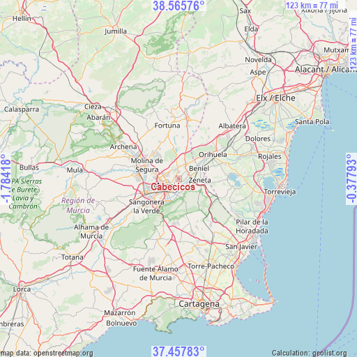
Cabecicos GPS coordinates[2]
38° 0' 50.004" North, 1° 4' 51.78" West
| Map corner | latitude | longitude |
|---|---|---|
| Upper-left | 38.56576°, | -1.78418° |
| Center: | 38.01389°, | -1.08105° |
| Lower-right: | 37.45783°, | -0.37793° |
| Map W x H: | 123.2×123.2 km | = 76.6×76.6mi |
| max Lat: | 43.74134° ⇑88.5% North |
| Cabecicos: | 38.01389° |
| min Lat: | ⇓11.5% South 27.64134° |
| min Long | Cabecicos | max Long |
| -18.00367° | -1.08105° | 4.2899° |
| W 76.5%⇐ | ⇒23.5% E |
Elevation
Elevation of Cabecicos is 32 m = 105 ft, and this is 566 m = 1857 ft below average elevation for this country.
| Max E: |
1682 m = 5518 ft | 93.9% |
| Avg. | 598 m = 1962 ft | |
| Cabecicos | 32 m = 105 ft | |
Min E: |
0 m = 0 ft | 6.1% |
See also: Spain elevation on elevation.city.
Geographical zone
Cabecicos is located in North temperate zone (between Tropic of Cancer and the Arctic Circle). Distance of this Northern Tropic circle is 1620.8 km =1007.1 mi to South.| Distance of | km | miles | from Cabecicos |
|---|---|---|---|
| North Pole | 5780.3 | 3591.7 | to North |
| Arctic Circle | 3174.4 | 1972.5 | to North |
| Tropic Cancer | 1620.8 | 1007.1 | to South |
| Equator | 4226.7 | 2626.3 | to South |


Nearby cities:
15 places around Cabecicos: (largest is in red/bold)
• Alcantarilla
12.9 km =8 mi,  247°
247°
• Alguazas
15.5 km =9.6 mi,  286°
286°
• Barrio de San José Obrero
3.2 km =2 mi,  60°
60°
• Beniel
7.8 km =4.8 mi, 62°
• Bigastro
16.9 km =10.5 mi,  71°
71°
• Cobatillas
4.6 km =2.9 mi,  4°
4°
• Esparragal
2.2 km =1.4 mi,  354°
354°
• Las Torres de Cotillas
14.2 km =8.8 mi,  276°
276°
• Lorquí
16.7 km =10.4 mi,  297°
297°
• Molina de Segura
12 km =7.5 mi, 292°
• Murcia
5.2 km =3.2 mi,  235°
235°
• Orihuela
14.4 km =8.9 mi, 56°
• Sangonera la Verde
14.6 km =9.1 mi,  229°
229°
• Santa Cruz
2.2 km =1.4 mi, 66°
• Santomera
6 km =3.7 mi,  28°
28°
Sources, notices
• [Note1] Compared only with cities in Spain existing in our database
• [Src1] Map data: © OpenStreetMap contributors (CC-BY-SA)
• [Src2] Other city data from geonames.org with taken over terms of usage.
• [Src3] Geographical zone / Annual Mean Temperature by Robert A. Rohde @ Wikipedia
