La Carlota geodata
La Carlota (Andalusia) is a populated place; located in Spain in Europe/Madrid (GMT+2) time zone. With population of 13,182 people, there are 698 cities with bigger population in this country. Compared to other cities in Spain, 90.3% of cities are located further ↑North; 71.6% of cities are located further →East and 80.4% of cities have higher elevation than La Carlota. Note1


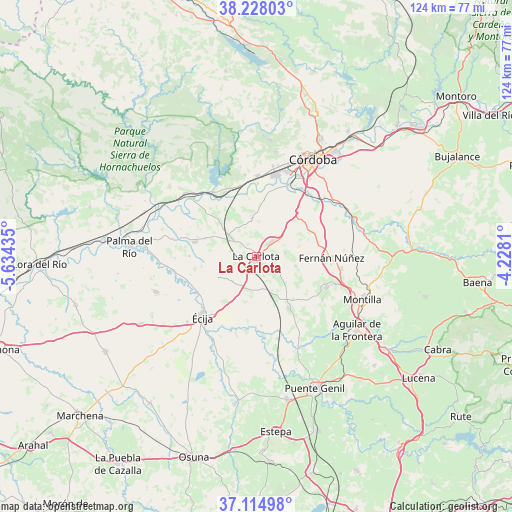
La Carlota GPS coordinates[2]
37° 40' 24.924" North, 4° 55' 52.392" West
| Map corner | latitude | longitude |
|---|---|---|
| Upper-left | 38.22803°, | -5.63435° |
| Center: | 37.67359°, | -4.93122° |
| Lower-right: | 37.11498°, | -4.2281° |
| Map W x H: | 123.8×123.8 km | = 76.9×76.9mi |
| max Lat: | 43.74134° ⇑90.3% North |
| La Carlota: | 37.67359° |
| min Lat: | ⇓9.7% South 27.64134° |
| min Long | La Carlota | max Long |
| -18.00367° | -4.93122° | 4.2899° |
| W 28.4%⇐ | ⇒71.6% E |
Elevation
Elevation of La Carlota is 213 m = 699 ft, and this is 385 m = 1263 ft below average elevation for this country.
| Max E: |
1682 m = 5518 ft | 80.4% |
| Avg. | 598 m = 1962 ft | |
| La Carlota | 213 m = 699 ft | |
Min E: |
0 m = 0 ft | 19.6% |
See also: Spain elevation on elevation.city.
Geographical zone
La Carlota is located in North temperate zone (between Tropic of Cancer and the Arctic Circle). Distance of this Northern Tropic circle is 1583 km =983.6 mi to South.| Distance of | km | miles | from La Carlota |
|---|---|---|---|
| North Pole | 5818.2 | 3615.3 | to North |
| Arctic Circle | 3212.3 | 1996 | to North |
| Tropic Cancer | 1583 | 983.6 | to South |
| Equator | 4188.9 | 2602.9 | to South |


Nearby cities:
15 places around La Carlota: (largest is in red/bold)
• Almodóvar del Río
17.1 km =10.6 mi,  332°
332°
• Cañada Rosal
25.9 km =16.1 mi,  251°
251°
• Fernán-Núñez
18 km =11.2 mi,  91°
91°
• Fuente Palmera
15.2 km =9.4 mi,  283°
283°
• Guadalcázar
9.4 km =5.8 mi,  353°
353°
• La Rambla
18.4 km =11.4 mi,  113°
113°
• La Victoria
7 km =4.3 mi,  83°
83°
• Montalbán de Córdoba
19.1 km =11.9 mi,  123°
123°
• Montemayor
20.7 km =12.9 mi,  97°
97°
• Montilla
27.6 km =17.1 mi, 110°
• Posadas
21.1 km =13.1 mi,  312°
312°
• San Sebastián de los Ballesteros
9.7 km =6 mi, 103°
• Santaella
14.5 km =9 mi,  147°
147°
• Villarrubia
19.8 km =12.3 mi,  7°
7°
• Écija
19.8 km =12.3 mi,  222°
222°
Sources, notices
• [Note1] Compared only with cities in Spain existing in our database
• [Src1] Map data: © OpenStreetMap contributors (CC-BY-SA)
• [Src2] Other city data from geonames.org with taken over terms of usage.
• [Src3] Geographical zone / Annual Mean Temperature by Robert A. Rohde @ Wikipedia
