La Lantejuela geodata
La Lantejuela (Andalusia) is a populated place; located in Spain in Europe/Madrid (GMT+2) time zone. With population of 3,792 people, there are 1520 cities with bigger population in this country. Compared to other cities in Spain, 92.4% of cities are located further ↑North; 75.4% of cities are located further →East and 84% of cities have higher elevation than La Lantejuela. Note1
Administrative division(s):
- Level 1: Andalusia
- Level 2: Provincia de Sevilla
- Level 3: Lantejuela, La


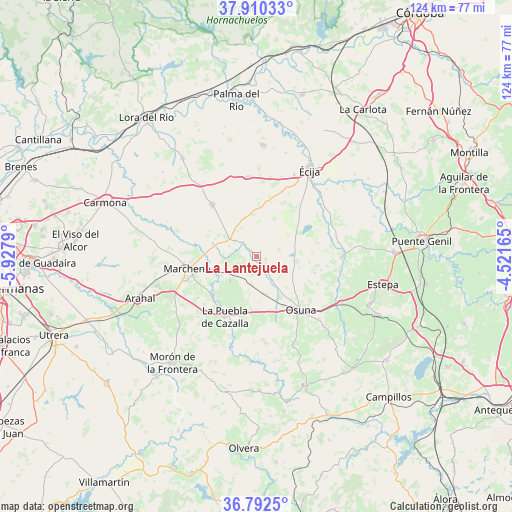
La Lantejuela GPS coordinates[2]
37° 21' 12.6" North, 5° 13' 29.172" West
| Map corner | latitude | longitude |
|---|---|---|
| Upper-left | 37.91033°, | -5.9279° |
| Center: | 37.3535°, | -5.22477° |
| Lower-right: | 36.7925°, | -4.52165° |
| Map W x H: | 124.3×124.3 km | = 77.2×77.2mi |
| max Lat: | 43.74134° ⇑92.4% North |
| La Lantejuela: | 37.3535° |
| min Lat: | ⇓7.6% South 27.64134° |
| min Long | La Lantejuela | max Long |
| -18.00367° | -5.22477° | 4.2899° |
| W 24.6%⇐ | ⇒75.4% E |
Elevation
Elevation of La Lantejuela is 156 m = 512 ft, and this is 442 m = 1450 ft below average elevation for this country.
| Max E: |
1682 m = 5518 ft | 84% |
| Avg. | 598 m = 1962 ft | |
| La Lantejuela | 156 m = 512 ft | |
Min E: |
0 m = 0 ft | 16% |
See also: Spain elevation on elevation.city.
Geographical zone
La Lantejuela is located in North temperate zone (between Tropic of Cancer and the Arctic Circle). Distance of this Northern Tropic circle is 1547.4 km =961.5 mi to South.| Distance of | km | miles | from La Lantejuela |
|---|---|---|---|
| North Pole | 5853.7 | 3637.3 | to North |
| Arctic Circle | 3247.9 | 2018.2 | to North |
| Tropic Cancer | 1547.4 | 961.5 | to South |
| Equator | 4153.3 | 2580.7 | to South |


Nearby cities:
15 places around La Lantejuela: (largest is in red/bold)
• Aguadulce
23.4 km =14.5 mi,  118°
118°
• Cañada Rosal
27.4 km =17 mi,  2°
2°
• El Arahal
30.1 km =18.7 mi,  250°
250°
• El Rubio
20.8 km =12.9 mi,  89°
89°
• Estepa
31.3 km =19.4 mi,  102°
102°
• Fuentes de Andalucía
16.3 km =10.1 mi,  318°
318°
• Gilena
29.7 km =18.5 mi,  112°
112°
• La Campana
29.9 km =18.6 mi, 323°
• La Luisiana
19.3 km =12 mi,  353°
353°
• La Puebla de Cazalla
16.6 km =10.3 mi,  207°
207°
• Marchena
17.2 km =10.7 mi,  260°
260°
• Marinaleda
23.5 km =14.6 mi, 85°
• Osuna
16.8 km =10.4 mi,  140°
140°
• Paradas
25.1 km =15.6 mi, 253°
• Écija
24.4 km =15.2 mi,  30°
30°
Sources, notices
• [Note1] Compared only with cities in Spain existing in our database
• [Src1] Map data: © OpenStreetMap contributors (CC-BY-SA)
• [Src2] Other city data from geonames.org with taken over terms of usage.
• [Src3] Geographical zone / Annual Mean Temperature by Robert A. Rohde @ Wikipedia
