Fernán-Núñez geodata
Fernán-Núñez (Andalusia) is a seat of a third-order administrative division; located in Spain in Europe/Madrid (GMT+2) time zone. With population of 9,374 people, there are 882 cities with bigger population in this country. Compared to other cities in Spain, 90.3% of cities are located further ↑North; 68.9% of cities are located further →East and 73.4% of cities have higher elevation than Fernán-Núñez. Note1


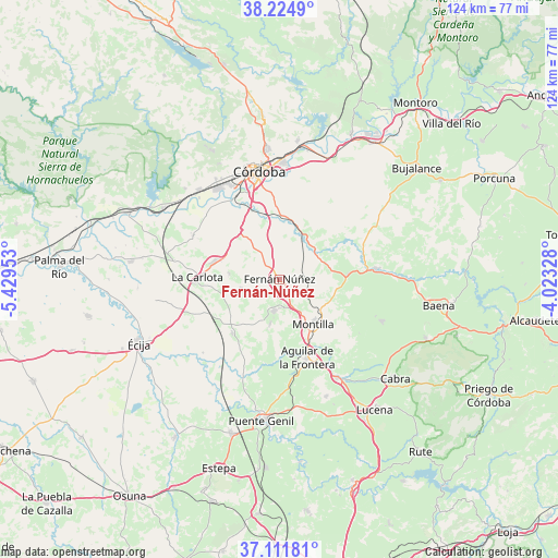
Fernán-Núñez GPS coordinates[2]
37° 40' 13.584" North, 4° 43' 35.04" West
| Map corner | latitude | longitude |
|---|---|---|
| Upper-left | 38.2249°, | -5.42953° |
| Center: | 37.67044°, | -4.7264° |
| Lower-right: | 37.11181°, | -4.02328° |
| Map W x H: | 123.8×123.8 km | = 76.9×76.9mi |
| max Lat: | 43.74134° ⇑90.3% North |
| Fernán-Núñez: | 37.67044° |
| min Lat: | ⇓9.7% South 27.64134° |
| min Long | Fernán-Núñez | max Long |
| -18.00367° | -4.7264° | 4.2899° |
| W 31.1%⇐ | ⇒68.9% E |
Elevation
Elevation of Fernán-Núñez is 325 m = 1066 ft, and this is 273 m = 896 ft below average elevation for this country.
| Max E: |
1682 m = 5518 ft | 73.4% |
| Avg. | 598 m = 1962 ft | |
| Fernán-Núñez | 325 m = 1066 ft | |
Min E: |
0 m = 0 ft | 26.6% |
See also: Spain elevation on elevation.city.
Geographical zone
Fernán-Núñez is located in North temperate zone (between Tropic of Cancer and the Arctic Circle). Distance of this Northern Tropic circle is 1582.6 km =983.4 mi to South.| Distance of | km | miles | from Fernán-Núñez |
|---|---|---|---|
| North Pole | 5818.5 | 3615.4 | to North |
| Arctic Circle | 3212.6 | 1996.2 | to North |
| Tropic Cancer | 1582.6 | 983.4 | to South |
| Equator | 4188.6 | 2602.7 | to South |


Nearby cities:
15 places around Fernán-Núñez: (largest is in red/bold)
• Aguilar
18.4 km =11.4 mi,  160°
160°
• Castro del Río
21.8 km =13.5 mi,  83°
83°
• Córdoba
24.9 km =15.5 mi,  350°
350°
• Espejo
15.2 km =9.4 mi,  86°
86°
• Guadalcázar
21.4 km =13.3 mi,  296°
296°
• La Carlota
18 km =11.2 mi,  271°
271°
• La Rambla
7.1 km =4.4 mi,  189°
189°
• La Victoria
11.1 km =6.9 mi,  276°
276°
• Montalbán de Córdoba
10.3 km =6.4 mi, 191°
• Montemayor
3.6 km =2.2 mi,  134°
134°
• Montilla
12.2 km =7.6 mi,  140°
140°
• Nueva-Carteya
24.6 km =15.3 mi,  112°
112°
• San Sebastián de los Ballesteros
8.8 km =5.5 mi,  257°
257°
• Santaella
15.8 km =9.8 mi,  220°
220°
• Villarrubia
25.1 km =15.6 mi,  322°
322°
Sources, notices
• [Note1] Compared only with cities in Spain existing in our database
• [Src1] Map data: © OpenStreetMap contributors (CC-BY-SA)
• [Src2] Other city data from geonames.org with taken over terms of usage.
• [Src3] Geographical zone / Annual Mean Temperature by Robert A. Rohde @ Wikipedia
