Torres geodata
Torres (Andalusia) is a seat of a third-order administrative division; located in Spain in Europe/Madrid (GMT+2) time zone. With population of 1,749 people, there are 2314 cities with bigger population in this country. Compared to other cities in Spain, 89.6% of cities are located further ↑North; 52.3% of cities are located further →East and 78.5% of cities have lower elevation than Torres. Note1


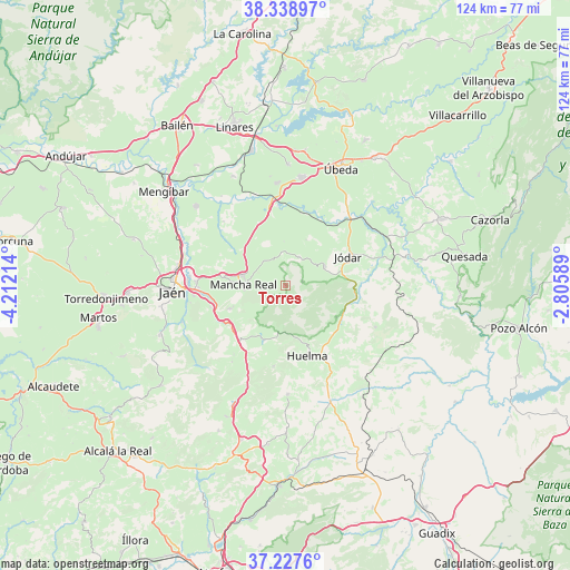
Torres GPS coordinates[2]
37° 47' 7.332" North, 3° 30' 32.472" West
| Map corner | latitude | longitude |
|---|---|---|
| Upper-left | 38.33897°, | -4.21214° |
| Center: | 37.78537°, | -3.50902° |
| Lower-right: | 37.2276°, | -2.80589° |
| Map W x H: | 123.6×123.6 km | = 76.8×76.8mi |
| max Lat: | 43.74134° ⇑89.6% North |
| Torres: | 37.78537° |
| min Lat: | ⇓10.4% South 27.64134° |
| min Long | Torres | max Long |
| -18.00367° | -3.50902° | 4.2899° |
| W 47.7%⇐ | ⇒52.3% E |
Elevation
Elevation of Torres is 885 m = 2904 ft, and this is 287 m = 942 ft above average elevation for this country.
| Max E: |
1682 m = 5518 ft | 21.5% |
| Torres | 885 m 2904 ft | |
| Avg. | 598 m = 1962 ft | |
Min E: |
0 m = 0 ft | 78.5% |
See also: Spain elevation on elevation.city.
Geographical zone
Torres is located in North temperate zone (between Tropic of Cancer and the Arctic Circle). Distance of this Northern Tropic circle is 1595.4 km =991.3 mi to South.| Distance of | km | miles | from Torres |
|---|---|---|---|
| North Pole | 5805.7 | 3607.5 | to North |
| Arctic Circle | 3199.8 | 1988.3 | to North |
| Tropic Cancer | 1595.4 | 991.3 | to South |
| Equator | 4201.3 | 2610.6 | to South |


Nearby cities:
15 places around Torres: (largest is in red/bold)
• Baeza
23.4 km =14.5 mi,  8°
8°
• Begíjar
22.3 km =13.9 mi,  355°
355°
• Bélmez de la Moraleda
13.1 km =8.1 mi,  121°
121°
• Cabra del Santo Cristo
21.5 km =13.4 mi,  114°
114°
• Cambil
12.8 km =8 mi,  202°
202°
• Huelma
15.9 km =9.9 mi,  164°
164°
• Ibros
26.2 km =16.3 mi,  1°
1°
• Jaén
24.8 km =15.4 mi,  265°
265°
• Jimena
6.8 km =4.2 mi,  24°
24°
• Jódar
15.1 km =9.4 mi,  65°
65°
• La Guardia de Jaén
16.9 km =10.5 mi,  253°
253°
• Lupión
23.7 km =14.7 mi,  351°
351°
• Mancha Real
9.1 km =5.7 mi, 270°
• Montejicar
23.7 km =14.7 mi,  179°
179°
• Pegalajar
13.3 km =8.3 mi, 247°
Sources, notices
• [Note1] Compared only with cities in Spain existing in our database
• [Src1] Map data: © OpenStreetMap contributors (CC-BY-SA)
• [Src2] Other city data from geonames.org with taken over terms of usage.
• [Src3] Geographical zone / Annual Mean Temperature by Robert A. Rohde @ Wikipedia
