Jimena geodata
Jimena (Andalusia) is a seat of a third-order administrative division; located in Spain in Europe/Madrid (GMT+2) time zone. With population of 1,496 people, there are 2465 cities with bigger population in this country. Compared to other cities in Spain, 89.4% of cities are located further ↑North; 51.7% of cities are located further →East and 55.2% of cities have higher elevation than Jimena. Note1


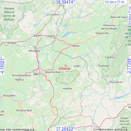
Jimena GPS coordinates[2]
37° 50' 29.652" North, 3° 28' 37.56" West
| Map corner | latitude | longitude |
|---|---|---|
| Upper-left | 38.39474°, | -4.18023° |
| Center: | 37.84157°, | -3.4771° |
| Lower-right: | 37.28422°, | -2.77398° |
| Map W x H: | 123.5×123.5 km | = 76.7×76.7mi |
| max Lat: | 43.74134° ⇑89.4% North |
| Jimena: | 37.84157° |
| min Lat: | ⇓10.6% South 27.64134° |
| min Long | Jimena | max Long |
| -18.00367° | -3.4771° | 4.2899° |
| W 48.3%⇐ | ⇒51.7% E |
Elevation
Elevation of Jimena is 593 m = 1946 ft, and this is 5 m = 16 ft below average elevation for this country.
| Max E: |
1682 m = 5518 ft | 55.2% |
| Avg. | 598 m = 1962 ft | |
| Jimena | 593 m = 1946 ft | |
Min E: |
0 m = 0 ft | 44.8% |
See also: Spain elevation on elevation.city.
Geographical zone
Jimena is located in North temperate zone (between Tropic of Cancer and the Arctic Circle). Distance of this Northern Tropic circle is 1601.7 km =995.2 mi to South.| Distance of | km | miles | from Jimena |
|---|---|---|---|
| North Pole | 5799.5 | 3603.6 | to North |
| Arctic Circle | 3193.6 | 1984.4 | to North |
| Tropic Cancer | 1601.7 | 995.2 | to South |
| Equator | 4207.6 | 2614.5 | to South |


Nearby cities:
15 places around Jimena: (largest is in red/bold)
• Baeza
16.9 km =10.5 mi,  1°
1°
• Begíjar
16.6 km =10.3 mi,  343°
343°
• Bélmez de la Moraleda
15.5 km =9.6 mi,  147°
147°
• Cabra del Santo Cristo
22.6 km =14 mi,  132°
132°
• Cambil
19.6 km =12.2 mi,  203°
203°
• Huelma
21.6 km =13.4 mi,  175°
175°
• Ibros
20.1 km =12.5 mi,  353°
353°
• Jódar
10.9 km =6.8 mi,  90°
90°
• La Guardia de Jaén
21.9 km =13.6 mi,  240°
240°
• Lupión
18.3 km =11.4 mi, 340°
• Mancha Real
13.4 km =8.3 mi, 242°
• Pegalajar
18.9 km =11.7 mi,  233°
233°
• Torreblascopedro
22.3 km =13.9 mi,  320°
320°
• Torres
6.8 km =4.2 mi, 204°
• Úbeda
21.3 km =13.2 mi,  26°
26°
Sources, notices
• [Note1] Compared only with cities in Spain existing in our database
• [Src1] Map data: © OpenStreetMap contributors (CC-BY-SA)
• [Src2] Other city data from geonames.org with taken over terms of usage.
• [Src3] Geographical zone / Annual Mean Temperature by Robert A. Rohde @ Wikipedia
