Benferri geodata
Benferri (Valencia) is a seat of a third-order administrative division; located in Spain in Europe/Madrid (GMT+2) time zone. With population of 1,494 people, there are 2466 cities with bigger population in this country. Compared to other cities in Spain, 87.6% of cities are located further ↑North; 77.5% of cities are located further ←West and 90.7% of cities have higher elevation than Benferri. Note1


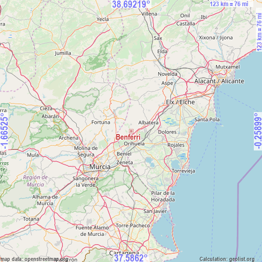
Benferri GPS coordinates[2]
38° 8' 28.644" North, 0° 57' 43.632" West
| Map corner | latitude | longitude |
|---|---|---|
| Upper-left | 38.69219°, | -1.66525° |
| Center: | 38.14129°, | -0.96212° |
| Lower-right: | 37.5862°, | -0.25899° |
| Map W x H: | 123×123 km | = 76.4×76.4mi |
| max Lat: | 43.74134° ⇑87.6% North |
| Benferri: | 38.14129° |
| min Lat: | ⇓12.4% South 27.64134° |
| min Long | Benferri | max Long |
| -18.00367° | -0.96212° | 4.2899° |
| W 77.5%⇐ | ⇒22.5% E |
Elevation
Elevation of Benferri is 55 m = 180 ft, and this is 543 m = 1781 ft below average elevation for this country.
| Max E: |
1682 m = 5518 ft | 90.7% |
| Avg. | 598 m = 1962 ft | |
| Benferri | 55 m = 180 ft | |
Min E: |
0 m = 0 ft | 9.3% |
See also: Spain elevation on elevation.city.
Geographical zone
Benferri is located in North temperate zone (between Tropic of Cancer and the Arctic Circle). Distance of this Northern Tropic circle is 1635 km =1015.9 mi to South.| Distance of | km | miles | from Benferri |
|---|---|---|---|
| North Pole | 5766.1 | 3582.9 | to North |
| Arctic Circle | 3160.3 | 1963.7 | to North |
| Tropic Cancer | 1635 | 1015.9 | to South |
| Equator | 4240.9 | 2635.2 | to South |


Nearby cities:
15 places around Benferri: (largest is in red/bold)
• Abanilla
9.9 km =6.2 mi,  315°
315°
• Albatera
9 km =5.6 mi,  62°
62°
• Benejúzar
12.9 km =8 mi,  123°
123°
• Beniel
11.1 km =6.9 mi,  198°
198°
• Bigastro
10.4 km =6.5 mi,  147°
147°
• Callosa de Segura
7.6 km =4.7 mi,  103°
103°
• Cobatillas
13.9 km =8.6 mi,  226°
226°
• Cox
6.5 km =4 mi,  89°
89°
• Granja de Rocamora
6.3 km =3.9 mi,  79°
79°
• Jacarilla
12 km =7.5 mi,  136°
136°
• Orihuela
6.5 km =4 mi,  165°
165°
• Rafal
10.7 km =6.6 mi,  112°
112°
• Redován
5.4 km =3.4 mi, 121°
• San Isidro
11.3 km =7 mi,  72°
72°
• Santomera
11.7 km =7.3 mi,  220°
220°
Sources, notices
• [Note1] Compared only with cities in Spain existing in our database
• [Src1] Map data: © OpenStreetMap contributors (CC-BY-SA)
• [Src2] Other city data from geonames.org with taken over terms of usage.
• [Src3] Geographical zone / Annual Mean Temperature by Robert A. Rohde @ Wikipedia
