Jabalquinto geodata
Jabalquinto (Andalusia) is a seat of a third-order administrative division; located in Spain in Europe/Madrid (GMT+2) time zone. With population of 2,390 people, there are 1947 cities with bigger population in this country. Compared to other cities in Spain, 88.5% of cities are located further ↑North; 55.7% of cities are located further →East and 62.7% of cities have higher elevation than Jabalquinto. Note1


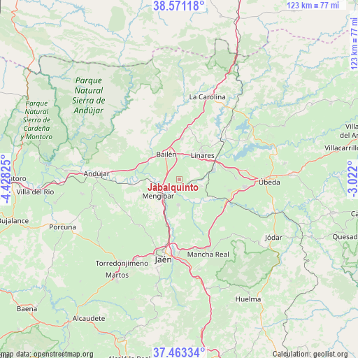
Jabalquinto GPS coordinates[2]
38° 1' 9.66" North, 3° 43' 30.432" West
| Map corner | latitude | longitude |
|---|---|---|
| Upper-left | 38.57118°, | -4.42825° |
| Center: | 38.01935°, | -3.72512° |
| Lower-right: | 37.46334°, | -3.022° |
| Map W x H: | 123.2×123.2 km | = 76.6×76.6mi |
| max Lat: | 43.74134° ⇑88.5% North |
| Jabalquinto: | 38.01935° |
| min Lat: | ⇓11.5% South 27.64134° |
| min Long | Jabalquinto | max Long |
| -18.00367° | -3.72512° | 4.2899° |
| W 44.3%⇐ | ⇒55.7% E |
Elevation
Elevation of Jabalquinto is 490 m = 1608 ft, and this is 108 m = 354 ft below average elevation for this country.
| Max E: |
1682 m = 5518 ft | 62.7% |
| Avg. | 598 m = 1962 ft | |
| Jabalquinto | 490 m = 1608 ft | |
Min E: |
0 m = 0 ft | 37.3% |
See also: Spain elevation on elevation.city.
Geographical zone
Jabalquinto is located in North temperate zone (between Tropic of Cancer and the Arctic Circle). Distance of this Northern Tropic circle is 1621.4 km =1007.5 mi to South.| Distance of | km | miles | from Jabalquinto |
|---|---|---|---|
| North Pole | 5779.7 | 3591.3 | to North |
| Arctic Circle | 3173.8 | 1972.1 | to North |
| Tropic Cancer | 1621.4 | 1007.5 | to South |
| Equator | 4227.4 | 2626.8 | to South |


Nearby cities:
15 places around Jabalquinto: (largest is in red/bold)
• Baeza
22.4 km =13.9 mi,  97°
97°
• Bailén
9.7 km =6 mi,  331°
331°
• Baños de la Encina
17.7 km =11 mi,  345°
345°
• Begíjar
17.4 km =10.8 mi, 102°
• Canena
21.5 km =13.4 mi,  81°
81°
• Cazalilla
14.4 km =8.9 mi,  254°
254°
• Espelúy
12.2 km =7.6 mi,  276°
276°
• Fuerte del Rey
21.3 km =13.2 mi,  220°
220°
• Guarromán
18.5 km =11.5 mi,  10°
10°
• Ibros
19.4 km =12.1 mi,  89°
89°
• Linares
11.5 km =7.1 mi,  42°
42°
• Lupión
15.8 km =9.8 mi, 99°
• Mengibar
9.2 km =5.7 mi,  233°
233°
• Torreblascopedro
8 km =5 mi,  107°
107°
• Villanueva de la Reina
16.8 km =10.4 mi,  264°
264°
Sources, notices
• [Note1] Compared only with cities in Spain existing in our database
• [Src1] Map data: © OpenStreetMap contributors (CC-BY-SA)
• [Src2] Other city data from geonames.org with taken over terms of usage.
• [Src3] Geographical zone / Annual Mean Temperature by Robert A. Rohde @ Wikipedia
