Fuencaliente geodata
Fuencaliente (Castille-La Mancha) is a populated place; located in Spain in Europe/Madrid (GMT+2) time zone. With population of 1,235 people, there are 2697 cities with bigger population in this country. Compared to other cities in Spain, 79.6% of cities are located further ↑North; 60.2% of cities are located further →East and 51.1% of cities have higher elevation than Fuencaliente. Note1
Administrative division(s):
- Level 1: Castille-La Mancha
- Level 2: Provincia de Ciudad Real
- Level 3: Malagón


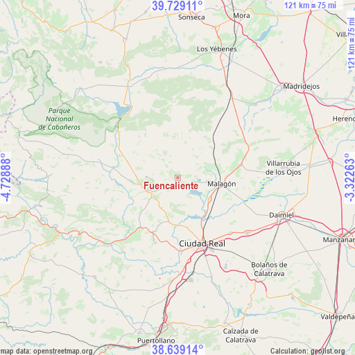
Fuencaliente GPS coordinates[2]
39° 11' 10.464" North, 4° 1' 32.736" West
| Map corner | latitude | longitude |
|---|---|---|
| Upper-left | 39.72911°, | -4.72888° |
| Center: | 39.18624°, | -4.02576° |
| Lower-right: | 38.63914°, | -3.32263° |
| Map W x H: | 121.2×121.2 km | = 75.3×75.3mi |
| max Lat: | 43.74134° ⇑79.6% North |
| Fuencaliente: | 39.18624° |
| min Lat: | ⇓20.4% South 27.64134° |
| min Long | Fuencaliente | max Long |
| -18.00367° | -4.02576° | 4.2899° |
| W 39.8%⇐ | ⇒60.2% E |
Elevation
Elevation of Fuencaliente is 647 m = 2123 ft, and this is 49 m = 161 ft above average elevation for this country.
| Max E: |
1682 m = 5518 ft | 51.1% |
| Fuencaliente | 647 m 2123 ft | |
| Avg. | 598 m = 1962 ft | |
Min E: |
0 m = 0 ft | 48.9% |
See also: Spain elevation on elevation.city.
Geographical zone
Fuencaliente is located in North temperate zone (between Tropic of Cancer and the Arctic Circle). Distance of this Northern Tropic circle is 1751.2 km =1088.1 mi to South.| Distance of | km | miles | from Fuencaliente |
|---|---|---|---|
| North Pole | 5650 | 3510.7 | to North |
| Arctic Circle | 3044.1 | 1891.5 | to North |
| Tropic Cancer | 1751.2 | 1088.1 | to South |
| Equator | 4357.1 | 2707.4 | to South |


Nearby cities:
15 places around Fuencaliente: (largest is in red/bold)
• Alcolea de Calatrava
23.5 km =14.6 mi,  199°
199°
• Ballesteros
11.2 km =7 mi,  27°
27°
• Carrión de Calatrava
25.9 km =16.1 mi,  135°
135°
• Ciudad Real
23.7 km =14.7 mi,  159°
159°
• El Robledo
22.3 km =13.9 mi,  279°
279°
• Fuente el Fresno
22.1 km =13.7 mi,  77°
77°
• Malagón
14.9 km =9.3 mi,  98°
98°
• Miguelturra
27.3 km =17 mi,  154°
154°
• Picón
15.4 km =9.6 mi,  191°
191°
• Piedrabuena
21.2 km =13.2 mi,  217°
217°
• Poblete
28.1 km =17.5 mi,  172°
172°
• Porzuna
11.9 km =7.4 mi,  248°
248°
• Torralba de Calatrava
30.2 km =18.8 mi,  128°
128°
• Urda
36.7 km =22.8 mi,  46°
46°
• Villarrubia de los Ojos
36.2 km =22.5 mi, 83°
Sources, notices
• [Note1] Compared only with cities in Spain existing in our database
• [Src1] Map data: © OpenStreetMap contributors (CC-BY-SA)
• [Src2] Other city data from geonames.org with taken over terms of usage.
• [Src3] Geographical zone / Annual Mean Temperature by Robert A. Rohde @ Wikipedia
