Alcántara geodata
Alcántara (Extremadura) is a seat of a third-order administrative division; located in Spain in Europe/Madrid (GMT+2) time zone. With population of 1,713 people, there are 2327 cities with bigger population in this country. Compared to other cities in Spain, 74% of cities are located further ↑North; 93.9% of cities are located further →East and 78.9% of cities have higher elevation than Alcántara. Note1


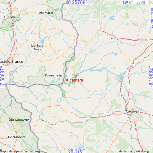
Alcántara GPS coordinates[2]
39° 43' 8.22" North, 6° 53' 1.5" West
| Map corner | latitude | longitude |
|---|---|---|
| Upper-left | 40.25766°, | -7.58687° |
| Center: | 39.71895°, | -6.88375° |
| Lower-right: | 39.176°, | -6.18062° |
| Map W x H: | 120.3×120.3 km | = 74.8×74.8mi |
| max Lat: | 43.74134° ⇑74% North |
| Alcántara: | 39.71895° |
| min Lat: | ⇓26% South 27.64134° |
| min Long | Alcántara | max Long |
| -18.00367° | -6.88375° | 4.2899° |
| W 6.1%⇐ | ⇒93.9% E |
Elevation
Elevation of Alcántara is 240 m = 787 ft, and this is 358 m = 1175 ft below average elevation for this country.
| Max E: |
1682 m = 5518 ft | 78.9% |
| Avg. | 598 m = 1962 ft | |
| Alcántara | 240 m = 787 ft | |
Min E: |
0 m = 0 ft | 21.1% |
See also: Spain elevation on elevation.city.
Geographical zone
Alcántara is located in North temperate zone (between Tropic of Cancer and the Arctic Circle). Distance of this Northern Tropic circle is 1810.4 km =1124.9 mi to South.| Distance of | km | miles | from Alcántara |
|---|---|---|---|
| North Pole | 5590.7 | 3473.9 | to North |
| Arctic Circle | 2984.8 | 1854.7 | to North |
| Tropic Cancer | 1810.4 | 1124.9 | to South |
| Equator | 4416.3 | 2744.2 | to South |


Nearby cities:
15 places around Alcántara: (largest is in red/bold)
• Acehuche
23.3 km =14.5 mi,  66°
66°
• Brozas
14.9 km =9.3 mi,  142°
142°
• Cachorrilla
28.5 km =17.7 mi,  39°
39°
• Carbajo
29.6 km =18.4 mi,  244°
244°
• Ceclavín
14.9 km =9.3 mi, 39°
• Garrovillas
28.5 km =17.7 mi,  91°
91°
• Mata de Alcántara
5.6 km =3.5 mi, 91°
• Membrío
25.8 km =16 mi,  214°
214°
• Navas del Madroño
22.5 km =14 mi,  118°
118°
• Pescueza
30 km =18.6 mi, 42°
• Piedras Albas
8.1 km =5 mi,  333°
333°
• Salorino
28.6 km =17.8 mi,  201°
201°
• Santiago de Alcántara
33.3 km =20.7 mi,  247°
247°
• Villa del Rey
8.5 km =5.3 mi, 140°
• Zarza la Mayor
17.7 km =11 mi,  6°
6°
Sources, notices
• [Note1] Compared only with cities in Spain existing in our database
• [Src1] Map data: © OpenStreetMap contributors (CC-BY-SA)
• [Src2] Other city data from geonames.org with taken over terms of usage.
• [Src3] Geographical zone / Annual Mean Temperature by Robert A. Rohde @ Wikipedia
