Villa del Rey geodata
Villa del Rey (Extremadura) is a seat of a third-order administrative division; located in Spain in Europe/Madrid (GMT+2) time zone. With population of 139 people, there are 5510 cities with bigger population in this country. Compared to other cities in Spain, 74.9% of cities are located further ↑North; 93.6% of cities are located further →East and 72.4% of cities have higher elevation than Villa del Rey. Note1
Administrative division(s):
- Level 1: Extremadura
- Level 2: Provincia de Cáceres
- Level 3: Villa del Rey


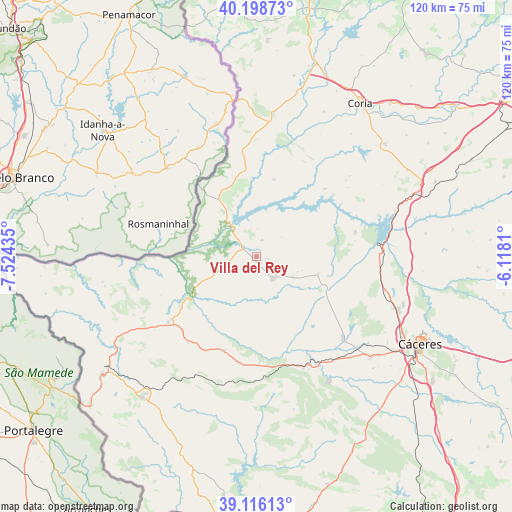
Villa del Rey GPS coordinates[2]
39° 39' 34.38" North, 6° 49' 16.392" West
| Map corner | latitude | longitude |
|---|---|---|
| Upper-left | 40.19873°, | -7.52435° |
| Center: | 39.65955°, | -6.82122° |
| Lower-right: | 39.11613°, | -6.1181° |
| Map W x H: | 120.4×120.4 km | = 74.8×74.8mi |
| max Lat: | 43.74134° ⇑74.9% North |
| Villa del Rey: | 39.65955° |
| min Lat: | ⇓25.1% South 27.64134° |
| min Long | Villa del Rey | max Long |
| -18.00367° | -6.82122° | 4.2899° |
| W 6.4%⇐ | ⇒93.6% E |
Elevation
Elevation of Villa del Rey is 340 m = 1115 ft, and this is 258 m = 846 ft below average elevation for this country.
| Max E: |
1682 m = 5518 ft | 72.4% |
| Avg. | 598 m = 1962 ft | |
| Villa del Rey | 340 m = 1115 ft | |
Min E: |
0 m = 0 ft | 27.6% |
See also: Spain elevation on elevation.city.
Geographical zone
Villa del Rey is located in North temperate zone (between Tropic of Cancer and the Arctic Circle). Distance of this Northern Tropic circle is 1803.8 km =1120.8 mi to South.| Distance of | km | miles | from Villa del Rey |
|---|---|---|---|
| North Pole | 5597.3 | 3478 | to North |
| Arctic Circle | 2991.4 | 1858.8 | to North |
| Tropic Cancer | 1803.8 | 1120.8 | to South |
| Equator | 4409.7 | 2740.1 | to South |


Nearby cities:
15 places around Villa del Rey: (largest is in red/bold)
• Acehuche
22.6 km =14 mi,  45°
45°
• Alcántara
8.5 km =5.3 mi,  320°
320°
• Aliseda
28.5 km =17.7 mi,  157°
157°
• Arroyo de la Luz
28.1 km =17.5 mi,  133°
133°
• Brozas
6.4 km =4 mi,  144°
144°
• Cachorrilla
31.3 km =19.4 mi,  24°
24°
• Ceclavín
18.6 km =11.6 mi,  12°
12°
• Garrovillas
23.9 km =14.9 mi,  76°
76°
• Mata de Alcántara
6.4 km =4 mi,  2°
2°
• Membrío
24.8 km =15.4 mi,  233°
233°
• Navas del Madroño
15 km =9.3 mi,  105°
105°
• Pescueza
32.4 km =20.1 mi,  27°
27°
• Piedras Albas
16.5 km =10.3 mi,  327°
327°
• Salorino
25.6 km =15.9 mi,  218°
218°
• Zarza la Mayor
24.4 km =15.2 mi,  351°
351°
Sources, notices
• [Note1] Compared only with cities in Spain existing in our database
• [Src1] Map data: © OpenStreetMap contributors (CC-BY-SA)
• [Src2] Other city data from geonames.org with taken over terms of usage.
• [Src3] Geographical zone / Annual Mean Temperature by Robert A. Rohde @ Wikipedia
