Fondón geodata
Fondón (Andalusia) is a seat of a third-order administrative division; located in Spain in Europe/Madrid (GMT+2) time zone. With population of 947 people, there are 3017 cities with bigger population in this country. Compared to other cities in Spain, 95.5% of cities are located further ↑North; 56.6% of cities are located further ←West and 75% of cities have lower elevation than Fondón. Note1


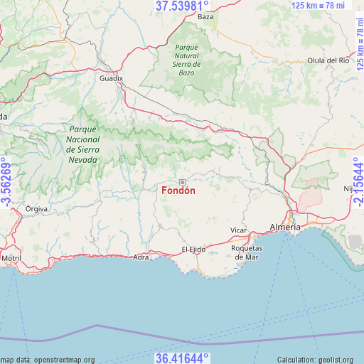
Fondón GPS coordinates[2]
36° 58' 48.72" North, 2° 51' 34.452" West
| Map corner | latitude | longitude |
|---|---|---|
| Upper-left | 37.53981°, | -3.56269° |
| Center: | 36.9802°, | -2.85957° |
| Lower-right: | 36.41644°, | -2.15644° |
| Map W x H: | 124.9×124.9 km | = 77.6×77.6mi |
| max Lat: | 43.74134° ⇑95.5% North |
| Fondón: | 36.9802° |
| min Lat: | ⇓4.5% South 27.64134° |
| min Long | Fondón | max Long |
| -18.00367° | -2.85957° | 4.2899° |
| W 56.6%⇐ | ⇒43.4% E |
Elevation
Elevation of Fondón is 851 m = 2792 ft, and this is 253 m = 830 ft above average elevation for this country.
| Max E: |
1682 m = 5518 ft | 25% |
| Fondón | 851 m 2792 ft | |
| Avg. | 598 m = 1962 ft | |
Min E: |
0 m = 0 ft | 75% |
See also: Spain elevation on elevation.city.
Geographical zone
Fondón is located in North temperate zone (between Tropic of Cancer and the Arctic Circle). Distance of this Northern Tropic circle is 1505.9 km =935.7 mi to South.| Distance of | km | miles | from Fondón |
|---|---|---|---|
| North Pole | 5895.2 | 3663.1 | to North |
| Arctic Circle | 3289.4 | 2043.9 | to North |
| Tropic Cancer | 1505.9 | 935.7 | to South |
| Equator | 4111.8 | 2555 | to South |


Nearby cities:
15 places around Fondón: (largest is in red/bold)
• Alcolea
9.1 km =5.7 mi,  266°
266°
• Almócita
6.6 km =4.1 mi,  67°
67°
• Bayárcal
13.4 km =8.3 mi,  294°
294°
• Beires
7 km =4.3 mi,  59°
59°
• Berja
16.8 km =10.4 mi,  208°
208°
• Canjáyar
11.2 km =7 mi, 72°
• Dalías
17.6 km =10.9 mi,  183°
183°
• Darrícal
16.5 km =10.3 mi,  245°
245°
• Instinción
17.7 km =11 mi,  85°
85°
• Laujar de Andarax
3.2 km =2 mi,  301°
301°
• Ohanes
12.1 km =7.5 mi, 57°
• Padules
7.9 km =4.9 mi,  75°
75°
• Paterna del Río
9.6 km =6 mi, 299°
• Rágol
15.9 km =9.9 mi, 83°
• Ugíjar
17.5 km =10.9 mi,  262°
262°
Sources, notices
• [Note1] Compared only with cities in Spain existing in our database
• [Src1] Map data: © OpenStreetMap contributors (CC-BY-SA)
• [Src2] Other city data from geonames.org with taken over terms of usage.
• [Src3] Geographical zone / Annual Mean Temperature by Robert A. Rohde @ Wikipedia
