Beires geodata
Beires (Andalusia) is a seat of a third-order administrative division; located in Spain in Europe/Madrid (GMT+2) time zone. With population of 120 people, there are 5697 cities with bigger population in this country. Compared to other cities in Spain, 95.1% of cities are located further ↑North; 57.6% of cities are located further ←West and 83.4% of cities have lower elevation than Beires. Note1


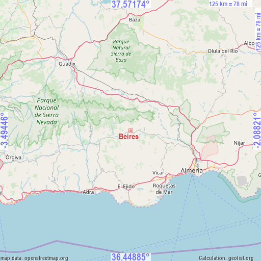
Beires GPS coordinates[2]
37° 0' 44.532" North, 2° 47' 28.824" West
| Map corner | latitude | longitude |
|---|---|---|
| Upper-left | 37.57174°, | -3.49446° |
| Center: | 37.01237°, | -2.79134° |
| Lower-right: | 36.44885°, | -2.08821° |
| Map W x H: | 124.9×124.9 km | = 77.6×77.6mi |
| max Lat: | 43.74134° ⇑95.1% North |
| Beires: | 37.01237° |
| min Lat: | ⇓4.9% South 27.64134° |
| min Long | Beires | max Long |
| -18.00367° | -2.79134° | 4.2899° |
| W 57.6%⇐ | ⇒42.4% E |
Elevation
Elevation of Beires is 932 m = 3058 ft, and this is 334 m = 1096 ft above average elevation for this country.
| Max E: |
1682 m = 5518 ft | 16.6% |
| Beires | 932 m 3058 ft | |
| Avg. | 598 m = 1962 ft | |
Min E: |
0 m = 0 ft | 83.4% |
See also: Spain elevation on elevation.city.
Geographical zone
Beires is located in North temperate zone (between Tropic of Cancer and the Arctic Circle). Distance of this Northern Tropic circle is 1509.5 km =938 mi to South.| Distance of | km | miles | from Beires |
|---|---|---|---|
| North Pole | 5891.7 | 3660.9 | to North |
| Arctic Circle | 3285.8 | 2041.7 | to North |
| Tropic Cancer | 1509.5 | 938 | to South |
| Equator | 4115.4 | 2557.2 | to South |


Nearby cities:
15 places around Beires: (largest is in red/bold)
• Abla
14.5 km =9 mi,  4°
4°
• Abrucena
13.3 km =8.3 mi,  357°
357°
• Albolodúy
15.2 km =9.4 mi,  81°
81°
• Alcolea
15.7 km =9.8 mi,  254°
254°
• Almócita
1.1 km =0.7 mi,  176°
176°
• Bentarique
15.5 km =9.6 mi,  99°
99°
• Canjáyar
4.6 km =2.9 mi,  93°
93°
• Fondón
7 km =4.3 mi,  239°
239°
• Illar
13.9 km =8.6 mi, 102°
• Instinción
11.8 km =7.3 mi, 100°
• Laujar de Andarax
9 km =5.6 mi,  257°
257°
• Ohanes
5 km =3.1 mi,  54°
54°
• Padules
2.2 km =1.4 mi,  135°
135°
• Paterna del Río
14.4 km =8.9 mi,  274°
274°
• Rágol
9.9 km =6.2 mi, 101°
Sources, notices
• [Note1] Compared only with cities in Spain existing in our database
• [Src1] Map data: © OpenStreetMap contributors (CC-BY-SA)
• [Src2] Other city data from geonames.org with taken over terms of usage.
• [Src3] Geographical zone / Annual Mean Temperature by Robert A. Rohde @ Wikipedia
