Almócita geodata
Almócita (Andalusia) is a seat of a third-order administrative division; located in Spain in Europe/Madrid (GMT+2) time zone. With population of 167 people, there are 5288 cities with bigger population in this country. Compared to other cities in Spain, 95.2% of cities are located further ↑North; 57.6% of cities are located further ←West and 72.7% of cities have lower elevation than Almócita. Note1


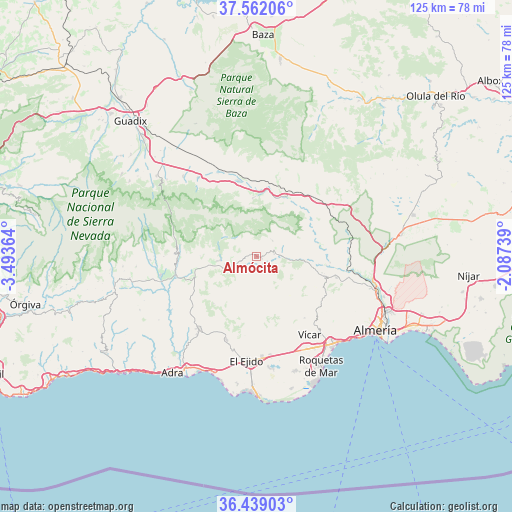
Almócita GPS coordinates[2]
37° 0' 9.432" North, 2° 47' 25.836" West
| Map corner | latitude | longitude |
|---|---|---|
| Upper-left | 37.56206°, | -3.49364° |
| Center: | 37.00262°, | -2.79051° |
| Lower-right: | 36.43903°, | -2.08739° |
| Map W x H: | 124.9×124.9 km | = 77.6×77.6mi |
| max Lat: | 43.74134° ⇑95.2% North |
| Almócita: | 37.00262° |
| min Lat: | ⇓4.8% South 27.64134° |
| min Long | Almócita | max Long |
| -18.00367° | -2.79051° | 4.2899° |
| W 57.6%⇐ | ⇒42.4% E |
Elevation
Elevation of Almócita is 832 m = 2730 ft, and this is 234 m = 768 ft above average elevation for this country.
| Max E: |
1682 m = 5518 ft | 27.3% |
| Almócita | 832 m 2730 ft | |
| Avg. | 598 m = 1962 ft | |
Min E: |
0 m = 0 ft | 72.7% |
See also: Spain elevation on elevation.city.
Geographical zone
Almócita is located in North temperate zone (between Tropic of Cancer and the Arctic Circle). Distance of this Northern Tropic circle is 1508.4 km =937.3 mi to South.| Distance of | km | miles | from Almócita |
|---|---|---|---|
| North Pole | 5892.8 | 3661.6 | to North |
| Arctic Circle | 3286.9 | 2042.4 | to North |
| Tropic Cancer | 1508.4 | 937.3 | to South |
| Equator | 4114.3 | 2556.5 | to South |


Nearby cities:
15 places around Almócita: (largest is in red/bold)
• Abla
15.6 km =9.7 mi,  4°
4°
• Abrucena
14.4 km =8.9 mi,  357°
357°
• Albolodúy
15.4 km =9.6 mi,  77°
77°
• Alcolea
15.5 km =9.6 mi,  258°
258°
• Beires
1.1 km =0.7 mi, 356°
• Bentarique
15.2 km =9.4 mi,  96°
96°
• Canjáyar
4.6 km =2.9 mi, 80°
• Fondón
6.6 km =4.1 mi,  247°
247°
• Illar
13.6 km =8.5 mi, 97°
• Instinción
11.6 km =7.2 mi, 95°
• Laujar de Andarax
8.9 km =5.5 mi, 264°
• Ohanes
5.7 km =3.5 mi,  45°
45°
• Padules
1.6 km =1 mi,  108°
108°
• Paterna del Río
14.6 km =9.1 mi,  278°
278°
• Rágol
9.7 km =6 mi,  94°
94°
Sources, notices
• [Note1] Compared only with cities in Spain existing in our database
• [Src1] Map data: © OpenStreetMap contributors (CC-BY-SA)
• [Src2] Other city data from geonames.org with taken over terms of usage.
• [Src3] Geographical zone / Annual Mean Temperature by Robert A. Rohde @ Wikipedia
