Bogarra geodata
Bogarra (Castille-La Mancha) is a populated place; located in Spain in Europe/Madrid (GMT+2) time zone. With population of 1,140 people, there are 2781 cities with bigger population in this country. Compared to other cities in Spain, 85.1% of cities are located further ↑North; 64.6% of cities are located further ←West and 75.2% of cities have lower elevation than Bogarra. Note1
Administrative division(s):
- Level 1: Castille-La Mancha
- Level 2: Provincia de Albacete
- Level 3: Alcaraz


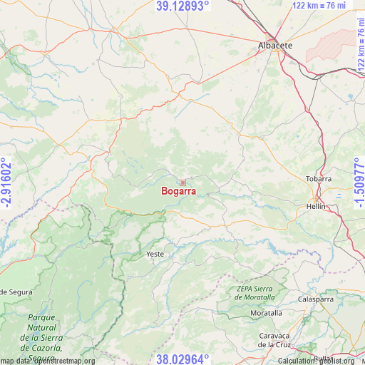
Bogarra GPS coordinates[2]
38° 34' 53.004" North, 2° 12' 46.44" West
| Map corner | latitude | longitude |
|---|---|---|
| Upper-left | 39.12893°, | -2.91602° |
| Center: | 38.58139°, | -2.2129° |
| Lower-right: | 38.02964°, | -1.50977° |
| Map W x H: | 122.2×122.2 km | = 75.9×75.9mi |
| max Lat: | 43.74134° ⇑85.1% North |
| Bogarra: | 38.58139° |
| min Lat: | ⇓14.9% South 27.64134° |
| min Long | Bogarra | max Long |
| -18.00367° | -2.2129° | 4.2899° |
| W 64.6%⇐ | ⇒35.4% E |
Elevation
Elevation of Bogarra is 853 m = 2799 ft, and this is 255 m = 837 ft above average elevation for this country.
| Max E: |
1682 m = 5518 ft | 24.8% |
| Bogarra | 853 m 2799 ft | |
| Avg. | 598 m = 1962 ft | |
Min E: |
0 m = 0 ft | 75.2% |
See also: Spain elevation on elevation.city.
Geographical zone
Bogarra is located in North temperate zone (between Tropic of Cancer and the Arctic Circle). Distance of this Northern Tropic circle is 1683.9 km =1046.3 mi to South.| Distance of | km | miles | from Bogarra |
|---|---|---|---|
| North Pole | 5717.2 | 3552.5 | to North |
| Arctic Circle | 3111.3 | 1933.3 | to North |
| Tropic Cancer | 1683.9 | 1046.3 | to South |
| Equator | 4289.8 | 2665.6 | to South |


Nearby cities:
15 places around Bogarra: (largest is in red/bold)
• Alcadozo
21.6 km =13.4 mi,  69°
69°
• Alcaraz
26 km =16.2 mi,  291°
291°
• Ayna
11.8 km =7.3 mi,  107°
107°
• Casas de Lázaro
21.2 km =13.2 mi,  353°
353°
• Elche de la Sierra
20.4 km =12.7 mi,  135°
135°
• Letur
25.8 km =16 mi,  158°
158°
• Liétor
22.9 km =14.2 mi,  100°
100°
• Masegoso
17.7 km =11 mi,  329°
329°
• Molinicos
12.9 km =8 mi,  190°
190°
• Paterna del Madera
11.6 km =7.2 mi,  278°
278°
• Peñas de San Pedro
24.4 km =15.2 mi,  47°
47°
• Pozuelo
27.2 km =16.9 mi,  20°
20°
• Riópar
22.5 km =14 mi,  246°
246°
• San Pedro
27.2 km =16.9 mi,  5°
5°
• Yeste
25.4 km =15.8 mi,  201°
201°
Sources, notices
• [Note1] Compared only with cities in Spain existing in our database
• [Src1] Map data: © OpenStreetMap contributors (CC-BY-SA)
• [Src2] Other city data from geonames.org with taken over terms of usage.
• [Src3] Geographical zone / Annual Mean Temperature by Robert A. Rohde @ Wikipedia
