Pozuelo geodata
Pozuelo (Castille-La Mancha) is a seat of a third-order administrative division; located in Spain in Europe/Madrid (GMT+2) time zone. With population of 673 people, there are 3454 cities with bigger population in this country. Compared to other cities in Spain, 83.2% of cities are located further ↑North; 66.1% of cities are located further ←West and 74.6% of cities have lower elevation than Pozuelo. Note1
Administrative division(s):
- Level 1: Castille-La Mancha
- Level 2: Provincia de Albacete
- Level 3: Pozuelo


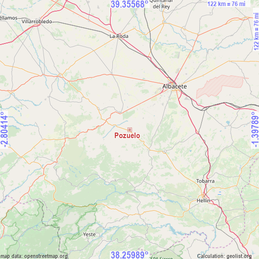
Pozuelo GPS coordinates[2]
38° 48' 35.604" North, 2° 6' 3.636" West
| Map corner | latitude | longitude |
|---|---|---|
| Upper-left | 39.35568°, | -2.80414° |
| Center: | 38.80989°, | -2.10101° |
| Lower-right: | 38.25989°, | -1.39789° |
| Map W x H: | 121.8×121.8 km | = 75.7×75.7mi |
| max Lat: | 43.74134° ⇑83.2% North |
| Pozuelo: | 38.80989° |
| min Lat: | ⇓16.8% South 27.64134° |
| min Long | Pozuelo | max Long |
| -18.00367° | -2.10101° | 4.2899° |
| W 66.1%⇐ | ⇒33.9% E |
Elevation
Elevation of Pozuelo is 848 m = 2782 ft, and this is 250 m = 820 ft above average elevation for this country.
| Max E: |
1682 m = 5518 ft | 25.4% |
| Pozuelo | 848 m 2782 ft | |
| Avg. | 598 m = 1962 ft | |
Min E: |
0 m = 0 ft | 74.6% |
See also: Spain elevation on elevation.city.
Geographical zone
Pozuelo is located in North temperate zone (between Tropic of Cancer and the Arctic Circle). Distance of this Northern Tropic circle is 1709.3 km =1062.1 mi to South.| Distance of | km | miles | from Pozuelo |
|---|---|---|---|
| North Pole | 5691.8 | 3536.7 | to North |
| Arctic Circle | 3085.9 | 1917.5 | to North |
| Tropic Cancer | 1709.3 | 1062.1 | to South |
| Equator | 4315.3 | 2681.4 | to South |


Nearby cities:
15 places around Pozuelo: (largest is in red/bold)
• Albacete
29.5 km =18.3 mi,  45°
45°
• Alcadozo
20.7 km =12.9 mi,  149°
149°
• Ayna
28.9 km =18 mi,  176°
176°
• Balazote
9.4 km =5.8 mi,  332°
332°
• Barrax
27.7 km =17.2 mi,  341°
341°
• Bogarra
27.2 km =16.9 mi,  200°
200°
• Casas de Lázaro
12.9 km =8 mi,  250°
250°
• El Ballestero
31 km =19.3 mi,  276°
276°
• Lezuza
26.9 km =16.7 mi,  305°
305°
• Masegoso
21.2 km =13.2 mi,  241°
241°
• Peñas de San Pedro
12.3 km =7.6 mi,  137°
137°
• Pozo-Cañada
31.7 km =19.7 mi,  91°
91°
• Pozohondo
19.1 km =11.9 mi,  121°
121°
• Robledo
30.8 km =19.1 mi,  259°
259°
• San Pedro
7.3 km =4.5 mi, 283°
Sources, notices
• [Note1] Compared only with cities in Spain existing in our database
• [Src1] Map data: © OpenStreetMap contributors (CC-BY-SA)
• [Src2] Other city data from geonames.org with taken over terms of usage.
• [Src3] Geographical zone / Annual Mean Temperature by Robert A. Rohde @ Wikipedia
