Alcadozo geodata
Alcadozo (Castille-La Mancha) is a seat of a third-order administrative division; located in Spain in Europe/Madrid (GMT+2) time zone. With population of 789 people, there are 3235 cities with bigger population in this country. Compared to other cities in Spain, 84.6% of cities are located further ↑North; 67.7% of cities are located further ←West and 82.9% of cities have lower elevation than Alcadozo. Note1
Administrative division(s):
- Level 1: Castille-La Mancha
- Level 2: Provincia de Albacete
- Level 3: Alcadozo


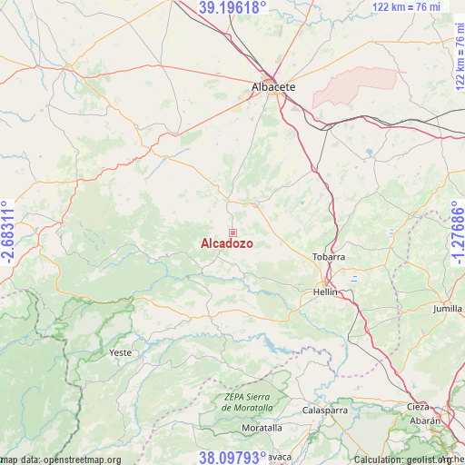
Alcadozo GPS coordinates[2]
38° 38' 56.976" North, 1° 58' 47.928" West
| Map corner | latitude | longitude |
|---|---|---|
| Upper-left | 39.19618°, | -2.68311° |
| Center: | 38.64916°, | -1.97998° |
| Lower-right: | 38.09793°, | -1.27686° |
| Map W x H: | 122.1×122.1 km | = 75.9×75.9mi |
| max Lat: | 43.74134° ⇑84.6% North |
| Alcadozo: | 38.64916° |
| min Lat: | ⇓15.4% South 27.64134° |
| min Long | Alcadozo | max Long |
| -18.00367° | -1.97998° | 4.2899° |
| W 67.7%⇐ | ⇒32.3% E |
Elevation
Elevation of Alcadozo is 927 m = 3041 ft, and this is 329 m = 1079 ft above average elevation for this country.
| Max E: |
1682 m = 5518 ft | 17.1% |
| Alcadozo | 927 m 3041 ft | |
| Avg. | 598 m = 1962 ft | |
Min E: |
0 m = 0 ft | 82.9% |
See also: Spain elevation on elevation.city.
Geographical zone
Alcadozo is located in North temperate zone (between Tropic of Cancer and the Arctic Circle). Distance of this Northern Tropic circle is 1691.5 km =1051 mi to South.| Distance of | km | miles | from Alcadozo |
|---|---|---|---|
| North Pole | 5709.7 | 3547.8 | to North |
| Arctic Circle | 3103.8 | 1928.6 | to North |
| Tropic Cancer | 1691.5 | 1051 | to South |
| Equator | 4297.4 | 2670.3 | to South |


Nearby cities:
15 places around Alcadozo: (largest is in red/bold)
• Ayna
14.2 km =8.8 mi,  219°
219°
• Balazote
30.1 km =18.7 mi,  330°
330°
• Bogarra
21.6 km =13.4 mi,  249°
249°
• Casas de Lázaro
26.3 km =16.3 mi,  300°
300°
• Elche de la Sierra
22.8 km =14.2 mi,  194°
194°
• Hellín
28.7 km =17.8 mi,  122°
122°
• Liétor
12.1 km =7.5 mi,  169°
169°
• Masegoso
30.2 km =18.8 mi,  284°
284°
• Molinicos
30.3 km =18.8 mi,  228°
228°
• Peñas de San Pedro
9.1 km =5.7 mi,  346°
346°
• Pozo-Cañada
27.3 km =17 mi,  51°
51°
• Pozohondo
9.9 km =6.2 mi,  36°
36°
• Pozuelo
20.7 km =12.9 mi, 329°
• San Pedro
26.3 km =16.3 mi,  318°
318°
• Tobarra
25.8 km =16 mi,  104°
104°
Sources, notices
• [Note1] Compared only with cities in Spain existing in our database
• [Src1] Map data: © OpenStreetMap contributors (CC-BY-SA)
• [Src2] Other city data from geonames.org with taken over terms of usage.
• [Src3] Geographical zone / Annual Mean Temperature by Robert A. Rohde @ Wikipedia
