Peñas de San Pedro geodata
Peñas de San Pedro (Castille-La Mancha) is a seat of a third-order administrative division; located in Spain in Europe/Madrid (GMT+2) time zone. With population of 1,259 people, there are 2674 cities with bigger population in this country. Compared to other cities in Spain, 83.9% of cities are located further ↑North; 67.5% of cities are located further ←West and 89.8% of cities have lower elevation than Peñas de San Pedro. Note1
Administrative division(s):
- Level 1: Castille-La Mancha
- Level 2: Provincia de Albacete
- Level 3: Peñas de San Pedro


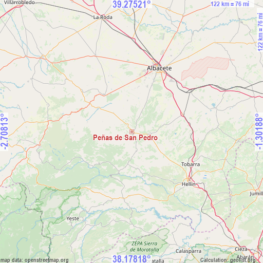
Peñas de San Pedro GPS coordinates[2]
38° 43' 43.68" North, 2° 0' 18" West
| Map corner | latitude | longitude |
|---|---|---|
| Upper-left | 39.27521°, | -2.70813° |
| Center: | 38.7288°, | -2.005° |
| Lower-right: | 38.17818°, | -1.30188° |
| Map W x H: | 122×122 km | = 75.8×75.8mi |
| max Lat: | 43.74134° ⇑83.9% North |
| Peñas de San Pedro: | 38.7288° |
| min Lat: | ⇓16.1% South 27.64134° |
| min Long | Peñas de San P | max Long |
| -18.00367° | -2.005° | 4.2899° |
| W 67.5%⇐ | ⇒32.5% E |
Elevation
Elevation of Peñas de San Pedro is 1028 m = 3373 ft, and this is 430 m = 1411 ft above average elevation for this country.
| Max E: |
1682 m = 5518 ft | 10.2% |
| Peñas de San Pedro | 1028 m 3373 ft | |
| Avg. | 598 m = 1962 ft | |
Min E: |
0 m = 0 ft | 89.8% |
See also: Spain elevation on elevation.city.
Geographical zone
Peñas de San Pedro is located in North temperate zone (between Tropic of Cancer and the Arctic Circle). Distance of this Northern Tropic circle is 1700.3 km =1056.5 mi to South.| Distance of | km | miles | from Peñas de San Pedro |
|---|---|---|---|
| North Pole | 5700.8 | 3542.3 | to North |
| Arctic Circle | 3094.9 | 1923.1 | to North |
| Tropic Cancer | 1700.3 | 1056.5 | to South |
| Equator | 4306.2 | 2675.7 | to South |


Nearby cities:
15 places around Peñas de San Pedro: (largest is in red/bold)
• Albacete
32.2 km =20 mi,  23°
23°
• Alcadozo
9.1 km =5.7 mi,  166°
166°
• Ayna
21 km =13 mi,  198°
198°
• Balazote
21.5 km =13.4 mi,  323°
323°
• Bogarra
24.4 km =15.2 mi,  227°
227°
• Casas de Lázaro
20.9 km =13 mi,  282°
282°
• Chinchilla de Monte Aragón
32.6 km =20.3 mi,  49°
49°
• Elche de la Sierra
31.1 km =19.3 mi,  186°
186°
• Liétor
21.2 km =13.2 mi, 167°
• Masegoso
27 km =16.8 mi,  267°
267°
• Pozo-Cañada
24.8 km =15.4 mi,  70°
70°
• Pozohondo
8.1 km =5 mi,  96°
96°
• Pozuelo
12.3 km =7.6 mi, 317°
• San Pedro
18.8 km =11.7 mi,  304°
304°
• Tobarra
31.1 km =19.3 mi,  119°
119°
Sources, notices
• [Note1] Compared only with cities in Spain existing in our database
• [Src1] Map data: © OpenStreetMap contributors (CC-BY-SA)
• [Src2] Other city data from geonames.org with taken over terms of usage.
• [Src3] Geographical zone / Annual Mean Temperature by Robert A. Rohde @ Wikipedia
