Abla geodata
Abla (Andalusia) is a seat of a third-order administrative division; located in Spain in Europe/Madrid (GMT+2) time zone. With population of 1,480 people, there are 2478 cities with bigger population in this country. Compared to other cities in Spain, 94.5% of cities are located further ↑North; 57.7% of cities are located further ←West and 77.3% of cities have lower elevation than Abla. Note1


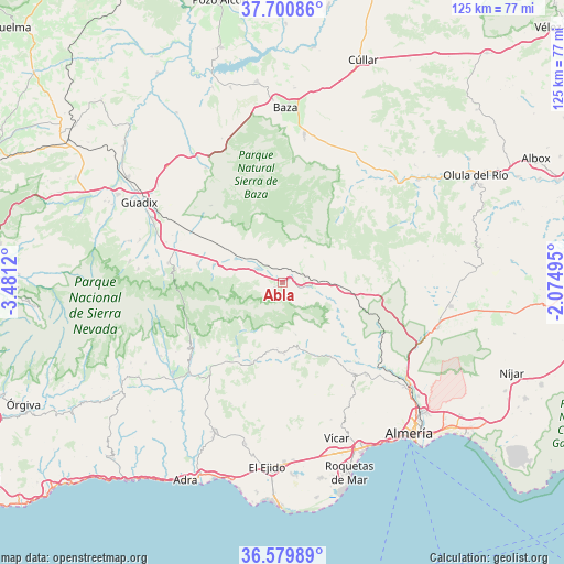
Abla GPS coordinates[2]
37° 8' 32.82" North, 2° 46' 41.088" West
| Map corner | latitude | longitude |
|---|---|---|
| Upper-left | 37.70086°, | -3.4812° |
| Center: | 37.14245°, | -2.77808° |
| Lower-right: | 36.57989°, | -2.07495° |
| Map W x H: | 124.6×124.6 km | = 77.4×77.4mi |
| max Lat: | 43.74134° ⇑94.5% North |
| Abla: | 37.14245° |
| min Lat: | ⇓5.5% South 27.64134° |
| min Long | Abla | max Long |
| -18.00367° | -2.77808° | 4.2899° |
| W 57.7%⇐ | ⇒42.3% E |
Elevation
Elevation of Abla is 873 m = 2864 ft, and this is 275 m = 902 ft above average elevation for this country.
| Max E: |
1682 m = 5518 ft | 22.7% |
| Abla | 873 m 2864 ft | |
| Avg. | 598 m = 1962 ft | |
Min E: |
0 m = 0 ft | 77.3% |
See also: Spain elevation on elevation.city.
Geographical zone
Abla is located in North temperate zone (between Tropic of Cancer and the Arctic Circle). Distance of this Northern Tropic circle is 1523.9 km =946.9 mi to South.| Distance of | km | miles | from Abla |
|---|---|---|---|
| North Pole | 5877.2 | 3651.9 | to North |
| Arctic Circle | 3271.3 | 2032.7 | to North |
| Tropic Cancer | 1523.9 | 946.9 | to South |
| Equator | 4129.9 | 2566.2 | to South |


Nearby cities:
15 places around Abla: (largest is in red/bold)
• Abrucena
2 km =1.2 mi,  236°
236°
• Albolodúy
18.4 km =11.4 mi,  131°
131°
• Almócita
15.6 km =9.7 mi,  184°
184°
• Beires
14.5 km =9 mi, 184°
• Canjáyar
15.2 km =9.4 mi,  166°
166°
• Dólar
19.3 km =12 mi,  282°
282°
• Fiñana
6.4 km =4 mi,  300°
300°
• Fondón
19.4 km =12.1 mi,  201°
201°
• Huéneja
15.7 km =9.8 mi, 283°
• Instinción
19.6 km =12.2 mi,  147°
147°
• Laujar de Andarax
19.2 km =11.9 mi,  211°
211°
• Ohanes
11.9 km =7.4 mi, 165°
• Padules
16.1 km =10 mi, 178°
• Paterna del Río
20.5 km =12.7 mi,  229°
229°
• Rágol
18.5 km =11.5 mi, 152°
Sources, notices
• [Note1] Compared only with cities in Spain existing in our database
• [Src1] Map data: © OpenStreetMap contributors (CC-BY-SA)
• [Src2] Other city data from geonames.org with taken over terms of usage.
• [Src3] Geographical zone / Annual Mean Temperature by Robert A. Rohde @ Wikipedia
