Badajoz geodata
Badajoz (Extremadura) is a seat of a third-order administrative division; located in Spain in Europe/Madrid (GMT+2) time zone. With population of 148,334 people, there are 59 cities with bigger population in this country. Compared to other cities in Spain, 82.4% of cities are located further ↑North; 94.2% of cities are located further →East and 81.7% of cities have higher elevation than Badajoz. Note1


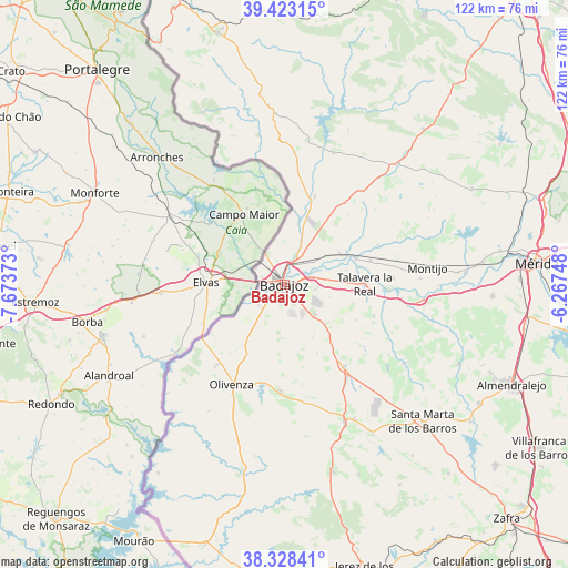
Badajoz GPS coordinates[2]
38° 52' 40.404" North, 6° 58' 14.196" West
| Map corner | latitude | longitude |
|---|---|---|
| Upper-left | 39.42315°, | -7.67373° |
| Center: | 38.87789°, | -6.97061° |
| Lower-right: | 38.32841°, | -6.26748° |
| Map W x H: | 121.7×121.7 km | = 75.6×75.6mi |
| max Lat: | 43.74134° ⇑82.4% North |
| Badajoz: | 38.87789° |
| min Lat: | ⇓17.6% South 27.64134° |
| min Long | Badajoz | max Long |
| -18.00367° | -6.97061° | 4.2899° |
| W 5.8%⇐ | ⇒94.2% E |
Elevation
Elevation of Badajoz is 192 m = 630 ft, and this is 406 m = 1332 ft below average elevation for this country.
| Max E: |
1682 m = 5518 ft | 81.7% |
| Avg. | 598 m = 1962 ft | |
| Badajoz | 192 m = 630 ft | |
Min E: |
0 m = 0 ft | 18.3% |
See also: Badajoz elevation on elevation.city.
Geographical zone
Badajoz is located in North temperate zone (between Tropic of Cancer and the Arctic Circle). Distance of this Northern Tropic circle is 1716.9 km =1066.8 mi to South.| Distance of | km | miles | from Badajoz |
|---|---|---|---|
| North Pole | 5684.2 | 3532 | to North |
| Arctic Circle | 3078.4 | 1912.8 | to North |
| Tropic Cancer | 1716.9 | 1066.8 | to South |
| Equator | 4322.8 | 2686.1 | to South |


Nearby cities:
15 places around Badajoz: (largest is in red/bold)
• Almendral
32.1 km =19.9 mi,  156°
156°
• Corte de Peleas
31 km =19.3 mi,  122°
122°
• Entrín Bajo
28.5 km =17.7 mi,  128°
128°
• La Albuera
21.9 km =13.6 mi,  144°
144°
• La Roca de la Sierra
35.4 km =22 mi,  43°
43°
• Lobón
30.2 km =18.8 mi,  96°
96°
• Montijo
30.7 km =19.1 mi,  83°
83°
• Olivenza
24.4 km =15.2 mi,  207°
207°
• Puebla de la Calzada
29.9 km =18.6 mi,  86°
86°
• Talavera La Real
17.5 km =10.9 mi, 89°
• Torre de Miguel Sesmero
32.5 km =20.2 mi,  152°
152°
• Torremayor
37.5 km =23.3 mi, 86°
• Valdelacalzada
23.4 km =14.5 mi, 86°
• Valverde de Leganés
23.1 km =14.4 mi,  182°
182°
• Villar del Rey
30.3 km =18.8 mi,  20°
20°
Sources, notices
• [Note1] Compared only with cities in Spain existing in our database
• [Src1] Map data: © OpenStreetMap contributors (CC-BY-SA)
• [Src2] Other city data from geonames.org with taken over terms of usage.
• [Src3] Geographical zone / Annual Mean Temperature by Robert A. Rohde @ Wikipedia
