Villar del Rey geodata
Villar del Rey (Extremadura) is a seat of a third-order administrative division; located in Spain in Europe/Madrid (GMT+2) time zone. With population of 2,279 people, there are 2010 cities with bigger population in this country. Compared to other cities in Spain, 79.9% of cities are located further ↑North; 93.7% of cities are located further →East and 78.5% of cities have higher elevation than Villar del Rey. Note1
Administrative division(s):
- Level 1: Extremadura
- Level 2: Provincia de Badajoz
- Level 3: Villar del Rey


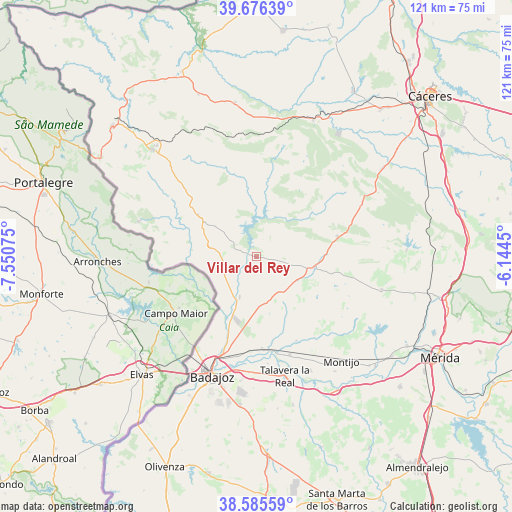
Villar del Rey GPS coordinates[2]
39° 7' 59.16" North, 6° 50' 51.432" West
| Map corner | latitude | longitude |
|---|---|---|
| Upper-left | 39.67639°, | -7.55075° |
| Center: | 39.1331°, | -6.84762° |
| Lower-right: | 38.58559°, | -6.1445° |
| Map W x H: | 121.3×121.3 km | = 75.4×75.4mi |
| max Lat: | 43.74134° ⇑79.9% North |
| Villar del Rey: | 39.1331° |
| min Lat: | ⇓20.1% South 27.64134° |
| min Long | Villar del Rey | max Long |
| -18.00367° | -6.84762° | 4.2899° |
| W 6.3%⇐ | ⇒93.7% E |
Elevation
Elevation of Villar del Rey is 247 m = 810 ft, and this is 351 m = 1152 ft below average elevation for this country.
| Max E: |
1682 m = 5518 ft | 78.5% |
| Avg. | 598 m = 1962 ft | |
| Villar del Rey | 247 m = 810 ft | |
Min E: |
0 m = 0 ft | 21.5% |
See also: Spain elevation on elevation.city.
Geographical zone
Villar del Rey is located in North temperate zone (between Tropic of Cancer and the Arctic Circle). Distance of this Northern Tropic circle is 1745.3 km =1084.5 mi to South.| Distance of | km | miles | from Villar del Rey |
|---|---|---|---|
| North Pole | 5655.9 | 3514.4 | to North |
| Arctic Circle | 3050 | 1895.2 | to North |
| Tropic Cancer | 1745.3 | 1084.5 | to South |
| Equator | 4351.2 | 2703.7 | to South |


Nearby cities:
15 places around Villar del Rey: (largest is in red/bold)
• Alburquerque
16.5 km =10.3 mi,  306°
306°
• Aliseda
34.9 km =21.7 mi,  22°
22°
• Badajoz
30.3 km =18.8 mi,  200°
200°
• Cordobilla de Lácara
35.5 km =22.1 mi,  87°
87°
• La Codosera
29.3 km =18.2 mi,  286°
286°
• La Nava de Santiago
30.5 km =19 mi,  104°
104°
• La Roca de la Sierra
13.9 km =8.6 mi, 100°
• Lobón
37.1 km =23.1 mi,  148°
148°
• Montijo
31.9 km =19.8 mi,  141°
141°
• Puebla de Obando
19.6 km =12.2 mi,  75°
75°
• Puebla de la Calzada
32.7 km =20.3 mi, 144°
• San Vicente de Alcántara
35.6 km =22.1 mi,  315°
315°
• Talavera La Real
29.2 km =18.1 mi,  166°
166°
• Torremayor
37.1 km =23.1 mi,  133°
133°
• Valdelacalzada
29.9 km =18.6 mi, 154°
Sources, notices
• [Note1] Compared only with cities in Spain existing in our database
• [Src1] Map data: © OpenStreetMap contributors (CC-BY-SA)
• [Src2] Other city data from geonames.org with taken over terms of usage.
• [Src3] Geographical zone / Annual Mean Temperature by Robert A. Rohde @ Wikipedia
