Olivenza geodata
Olivenza (Extremadura) is a seat of a third-order administrative division; located in Spain in Europe/Madrid (GMT+2) time zone. With population of 11,977 people, there are 750 cities with bigger population in this country. Compared to other cities in Spain, 84.4% of cities are located further ↑North; 94.5% of cities are located further →East and 77.6% of cities have higher elevation than Olivenza. Note1


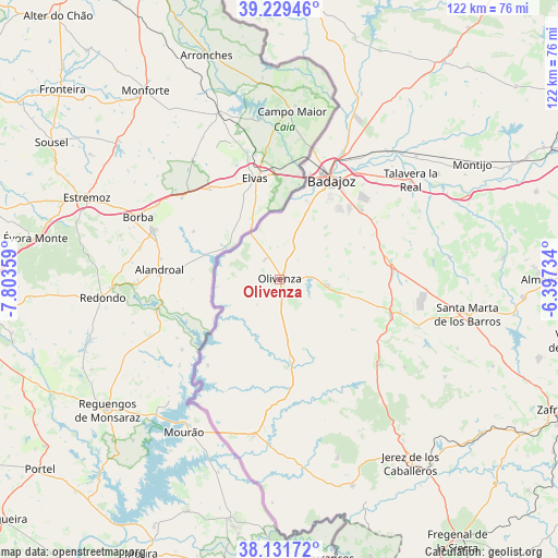
Olivenza GPS coordinates[2]
38° 40' 57.684" North, 7° 6' 1.656" West
| Map corner | latitude | longitude |
|---|---|---|
| Upper-left | 39.22946°, | -7.80359° |
| Center: | 38.68269°, | -7.10046° |
| Lower-right: | 38.13172°, | -6.39734° |
| Map W x H: | 122.1×122.1 km | = 75.9×75.9mi |
| max Lat: | 43.74134° ⇑84.4% North |
| Olivenza: | 38.68269° |
| min Lat: | ⇓15.6% South 27.64134° |
| min Long | Olivenza | max Long |
| -18.00367° | -7.10046° | 4.2899° |
| W 5.5%⇐ | ⇒94.5% E |
Elevation
Elevation of Olivenza is 262 m = 860 ft, and this is 336 m = 1102 ft below average elevation for this country.
| Max E: |
1682 m = 5518 ft | 77.6% |
| Avg. | 598 m = 1962 ft | |
| Olivenza | 262 m = 860 ft | |
Min E: |
0 m = 0 ft | 22.4% |
See also: Spain elevation on elevation.city.
Geographical zone
Olivenza is located in North temperate zone (between Tropic of Cancer and the Arctic Circle). Distance of this Northern Tropic circle is 1695.2 km =1053.3 mi to South.| Distance of | km | miles | from Olivenza |
|---|---|---|---|
| North Pole | 5705.9 | 3545.5 | to North |
| Arctic Circle | 3100.1 | 1926.3 | to North |
| Tropic Cancer | 1695.2 | 1053.3 | to South |
| Equator | 4301.1 | 2672.6 | to South |


Nearby cities:
15 places around Olivenza: (largest is in red/bold)
• Alconchel
18.7 km =11.6 mi,  172°
172°
• Almendral
25.4 km =15.8 mi,  107°
107°
• Badajoz
24.4 km =15.2 mi,  27°
27°
• Barcarrota
28.7 km =17.8 mi,  130°
130°
• Cheles
24.6 km =15.3 mi,  219°
219°
• Entrín Bajo
33.8 km =21 mi,  83°
83°
• Higuera de Vargas
28.4 km =17.6 mi,  157°
157°
• La Albuera
24.4 km =15.2 mi, 80°
• Nogales
32.4 km =20.1 mi, 109°
• Salvaleón
33.4 km =20.8 mi, 125°
• Talavera La Real
36 km =22.4 mi,  52°
52°
• Torre de Miguel Sesmero
27.4 km =17 mi,  104°
104°
• Táliga
18.6 km =11.6 mi, 157°
• Valverde de Leganés
10.5 km =6.5 mi, 97°
• Villanueva del Fresno
34.6 km =21.5 mi,  189°
189°
Sources, notices
• [Note1] Compared only with cities in Spain existing in our database
• [Src1] Map data: © OpenStreetMap contributors (CC-BY-SA)
• [Src2] Other city data from geonames.org with taken over terms of usage.
• [Src3] Geographical zone / Annual Mean Temperature by Robert A. Rohde @ Wikipedia
